IMAGES TAKEN NEAR TO
North Galson, ISLE OF LEWIS, HS2 0SJ
Introduction
This page details the photographs taken nearby to HS2 0SJ by members of the Geograph project.
The Geograph project started in 2005 with the aim of publishing, organising and preserving representative images for every square kilometre of Great Britain, Ireland and the Isle of Man.

There are currently over 7.5m images from over14,400 individuals and you can help contribute to the project by visiting https://www.geograph.org.uk
Image Map (Loading...)


Getting Data...Please wait
Leaflet Map data © OpenStreetMap
Images are licensed for reuse under creativecommons.org/licenses/by-sa/2.0
Notes
- Clicking on the map will re-center to the selected point.
- The higher the marker number, the further away the image location is from the centre of the postcode.
Image Listing (2 Images Found)
Images are licensed for reuse under creativecommons.org/licenses/by-sa/2.0
Image
Details
Distance
1
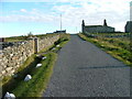
Ruined Crofthouse at Gabhsann
The township of Gabhsann consists of two settlements, Gabhsann bho Dheas and Gabhsann bho Thuath.
Image: © Dave Fergusson
Taken: 29 Sep 2007
0.13 miles
2
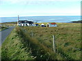
Croft Overlooking the Atlantic
In the township of Gabhsann.
Image: © Dave Fergusson
Taken: 29 Sep 2007
0.22 miles