IMAGES TAKEN NEAR TO
Glen, ISLE OF LEWIS, HS2 0ND
Introduction
This page details the photographs taken nearby to Glen, HS2 0ND by members of the Geograph project.
The Geograph project started in 2005 with the aim of publishing, organising and preserving representative images for every square kilometre of Great Britain, Ireland and the Isle of Man.

There are currently over 7.5m images from over14,400 individuals and you can help contribute to the project by visiting https://www.geograph.org.uk
Image Map (Loading...)


Getting Data...Please wait
Leaflet Map data © OpenStreetMap
Images are licensed for reuse under creativecommons.org/licenses/by-sa/2.0
Notes
- Clicking on the map will re-center to the selected point.
- The higher the marker number, the further away the image location is from the centre of the postcode.
Image Listing (17 Images Found)
Images are licensed for reuse under creativecommons.org/licenses/by-sa/2.0
Image
Details
Distance
1
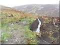
Gleann Tholastaidh
Newly cleared drainage channel at the end of the road.
Image: © M J Richardson
Taken: 12 May 2013
0.04 miles
2
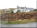
House at Gleann Tholastaidh
At the end of the road, a spur from the B895 main road to Tholastaidh.
Image: © M J Richardson
Taken: 12 May 2013
0.04 miles
3
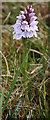
Heath Spotted Orchid (Dactylorhiza maculata)
Common on acid soils, this is one of the earliest orchids to appear in spring.
Image: © Anne Burgess
Taken: 14 May 2011
0.10 miles
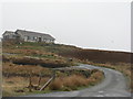
5
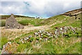
Bun a'Ghlinne
The houses at the foot of the slope are all ruinous, but the ones higher up, close to the road, are inhabited. No wonder, because as well as poor access the ground down here is very wet and boggy.
Image: © Anne Burgess
Taken: 14 May 2011
0.12 miles
6
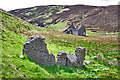
Gleann Tholastaidh (Glen Tolsta)
Sited at the end of a side road, Gleann Tholastaidh is the site of several ruined houses. The construction of the nearest one looks like beach pebbles in a cement matrix.
Image: © Anne Burgess
Taken: 14 May 2011
0.13 miles
7
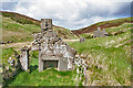
Ruined Croft Houses
I am a little surprised to see that the gables are apparently built of cemented rubble. These houses cannot have been all that old when they were abandoned.
Image: © Anne Burgess
Taken: 14 May 2011
0.13 miles
8
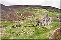
Ruin at Bun a'Ghlinne
One of several ruins at the foot of Gleann Tolastadh.
Image: © Anne Burgess
Taken: 14 May 2011
0.15 miles
9
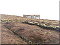
Battling the elements
A polytunnel on the moor above Gleann Tholastaidh, with deer protection as well.
Image: © M J Richardson
Taken: 12 May 2013
0.15 miles
10
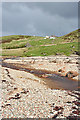
Bun a'Ghlinne
Looking up from the beach of Port Bun a'Ghlinne past the ruined houses to the ones further uphill which are still inhabited.
Image: © Anne Burgess
Taken: 14 May 2011
0.16 miles