IMAGES TAKEN NEAR TO
Vatisker, ISLE OF LEWIS, HS2 0LB
Introduction
This page details the photographs taken nearby to HS2 0LB by members of the Geograph project.
The Geograph project started in 2005 with the aim of publishing, organising and preserving representative images for every square kilometre of Great Britain, Ireland and the Isle of Man.

There are currently over 7.5m images from over14,400 individuals and you can help contribute to the project by visiting https://www.geograph.org.uk
Image Map (Loading...)


Getting Data...Please wait
Leaflet Map data © OpenStreetMap
Images are licensed for reuse under creativecommons.org/licenses/by-sa/2.0
Notes
- Clicking on the map will re-center to the selected point.
- The higher the marker number, the further away the image location is from the centre of the postcode.
Image Listing (2 Images Found)
Images are licensed for reuse under creativecommons.org/licenses/by-sa/2.0
Image
Details
Distance
1
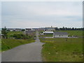
Back School Road
A view looking along Back School Road towards the school. The school is a combined Primary and S1-S2 school with around 200 pupils.
Image: © Donald Lawson
Taken: 1 Jul 2006
0.11 miles
2
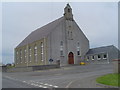
Back Free Church
The Free Church of Scotland own this church. It is the largest church in the Broad Bay area.
Image: © Donald Lawson
Taken: 1 Jul 2006
0.21 miles