IMAGES TAKEN NEAR TO
Church Road, ISLE OF LEWIS, HS2 0EY
Introduction
This page details the photographs taken nearby to Church Road, HS2 0EY by members of the Geograph project.
The Geograph project started in 2005 with the aim of publishing, organising and preserving representative images for every square kilometre of Great Britain, Ireland and the Isle of Man.

There are currently over 7.5m images from over14,400 individuals and you can help contribute to the project by visiting https://www.geograph.org.uk
Image Map
Images are licensed for reuse under creativecommons.org/licenses/by-sa/2.0
Notes
- Clicking on the map will re-center to the selected point.
- The higher the marker number, the further away the image location is from the centre of the postcode.
Image Listing (1 Images Found)
Images are licensed for reuse under creativecommons.org/licenses/by-sa/2.0
Image
Details
Distance
1
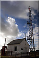
Coastguard Communications Site
This is the communications mast for Stornoway Coastguard http://www.mcga.gov.uk/c4mca/mcga-dops-regional/scotni-region/dops_-_all-scotni_region-sar/dops_-_all-scotni_region-sar-north/dops_-_all-scotni_region-sar-north-stwy_home.htm that dominates the horizon around Flesherin and Brocair. The building used to be the base for Coastguard Life Saving Apparatus when the Breaches Buoy equipment was used. It now houses the communications equipment that is vital for distress and safety communications for shipping in the North Minch.
Image: © Martin Collins
Taken: 13 Mar 2007
0.12 miles