IMAGES TAKEN NEAR TO
Newvalley, ISLE OF LEWIS, HS2 0DW
Introduction
This page details the photographs taken nearby to HS2 0DW by members of the Geograph project.
The Geograph project started in 2005 with the aim of publishing, organising and preserving representative images for every square kilometre of Great Britain, Ireland and the Isle of Man.

There are currently over 7.5m images from over14,400 individuals and you can help contribute to the project by visiting https://www.geograph.org.uk
Image Map (Loading...)


Getting Data...Please wait
Leaflet Map data © OpenStreetMap
Images are licensed for reuse under creativecommons.org/licenses/by-sa/2.0
Notes
- Clicking on the map will re-center to the selected point.
- The higher the marker number, the further away the image location is from the centre of the postcode.
Image Listing (3 Images Found)
Images are licensed for reuse under creativecommons.org/licenses/by-sa/2.0
Image
Details
Distance
1
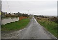
An Gleann Ur
Road serving houses built along a ridge.
Image: © Richard Webb
Taken: 9 Apr 2009
0.04 miles
2
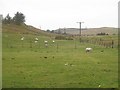
An Gleann Ur
The valley floor with grazing sheep. Lambing has just begun.
Image: © Richard Webb
Taken: 9 Apr 2009
0.21 miles
3
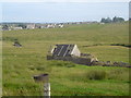
Ruin, Benside
A ruined house which has been used as a barn. The Laxdale river can be seen meandering in the background.
Image: © Donald Lawson
Taken: 21 Jul 2006
0.22 miles