IMAGES TAKEN NEAR TO
Maryhill, ISLE OF LEWIS, HS2 0DJ
Introduction
This page details the photographs taken nearby to HS2 0DJ by members of the Geograph project.
The Geograph project started in 2005 with the aim of publishing, organising and preserving representative images for every square kilometre of Great Britain, Ireland and the Isle of Man.

There are currently over 7.5m images from over14,400 individuals and you can help contribute to the project by visiting https://www.geograph.org.uk
Image Map (Loading...)


Getting Data...Please wait
Leaflet Map data © OpenStreetMap
Images are licensed for reuse under creativecommons.org/licenses/by-sa/2.0
Notes
- Clicking on the map will re-center to the selected point.
- The higher the marker number, the further away the image location is from the centre of the postcode.
Image Listing (8 Images Found)
Images are licensed for reuse under creativecommons.org/licenses/by-sa/2.0
Image
Details
Distance
1
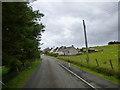
Houses at Cnoc Mairi
A row of various types and ages of houses at Maryhill.
Image: © John Haynes
Taken: 13 Jul 2016
0.05 miles
2
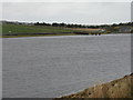
The east end of Loch ?irigh na Lic
With its outflow at Cnoc Màiri/Maryhill.
Image: © M J Richardson
Taken: 14 May 2013
0.12 miles
4
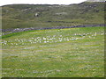
Resting gulls
Not far from the landfill site these are gulls are recovering from an early morning scavenging. The white blobs in the "unimproved" land beyond the dyke are cotton grass plants.
Image: © John Haynes
Taken: 13 Jul 2016
0.17 miles
5
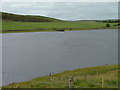
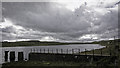
Loch Airigh na Lic
In times past, Stornoway's water supply came from this loch. The structure on the opposite bank was the point where the water was drawn off to enter the water mains. Thanks to John J Maclennan for this information.
Image: © Dave Fergusson
Taken: 10 Jul 2006
0.18 miles
6
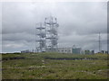
Up near the cloud at the WT Station
When you get up near the masts the reason for choosing the site is obvious as the Harris mountains are in view.
Image: © John Haynes
Taken: 13 Jul 2016
0.19 miles
7
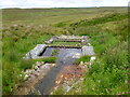
Leachate outfall from landfill site
There is a processing plant for the leachate before it is discharged into a burn that flows towards Loch Àirigh na Lich
Image: © John Haynes
Taken: 13 Jul 2016
0.19 miles
8
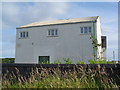
Marybank Depository
A store building which has been used by the local council for many years. It looks out of place on a road with only residential houses.
Image: © Donald Lawson
Taken: 21 Jul 2006
0.22 miles