IMAGES TAKEN NEAR TO
Marybank, ISLE OF LEWIS, HS2 0DD
Introduction
This page details the photographs taken nearby to HS2 0DD by members of the Geograph project.
The Geograph project started in 2005 with the aim of publishing, organising and preserving representative images for every square kilometre of Great Britain, Ireland and the Isle of Man.

There are currently over 7.5m images from over14,400 individuals and you can help contribute to the project by visiting https://www.geograph.org.uk
Image Map
Images are licensed for reuse under creativecommons.org/licenses/by-sa/2.0
Notes
- Clicking on the map will re-center to the selected point.
- The higher the marker number, the further away the image location is from the centre of the postcode.
Image Listing (2 Images Found)
Images are licensed for reuse under creativecommons.org/licenses/by-sa/2.0
Image
Details
Distance
1
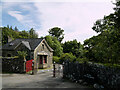
Lews Castle, Marybank Lodge and Gateway
Mid-nineteenth century gate and gatehouse to Lews Castle. Category C listed building (LB18817 https://portal.historicenvironment.scot/designation/LB18817 Historic Environment Scotland).
Image: © David Dixon
Taken: 18 Aug 2023
0.05 miles
2
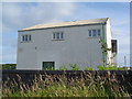
Marybank Depository
A store building which has been used by the local council for many years. It looks out of place on a road with only residential houses.
Image: © Donald Lawson
Taken: 21 Jul 2006
0.25 miles