IMAGES TAKEN NEAR TO
Braighe Road, ISLE OF LEWIS, HS2 0BQ
Introduction
This page details the photographs taken nearby to Braighe Road, HS2 0BQ by members of the Geograph project.
The Geograph project started in 2005 with the aim of publishing, organising and preserving representative images for every square kilometre of Great Britain, Ireland and the Isle of Man.

There are currently over 7.5m images from over14,400 individuals and you can help contribute to the project by visiting https://www.geograph.org.uk
Image Map
Images are licensed for reuse under creativecommons.org/licenses/by-sa/2.0
Notes
- Clicking on the map will re-center to the selected point.
- The higher the marker number, the further away the image location is from the centre of the postcode.
Image Listing (2 Images Found)
Images are licensed for reuse under creativecommons.org/licenses/by-sa/2.0
Image
Details
Distance
1
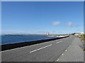
The Br?igh
This photo of the Bràigh was taken on the A866 on the Bràigh beside the Cemetery at the Eye Peninsula end, the picture captures the shoreline and above are the houses on the Bràigh on the right merging into Parkend further behind
Image: © Angus Peck
Taken: 27 May 2004
0.16 miles