IMAGES TAKEN NEAR TO
Holm, ISLE OF LEWIS, HS2 0AH
Introduction
This page details the photographs taken nearby to HS2 0AH by members of the Geograph project.
The Geograph project started in 2005 with the aim of publishing, organising and preserving representative images for every square kilometre of Great Britain, Ireland and the Isle of Man.

There are currently over 7.5m images from over14,400 individuals and you can help contribute to the project by visiting https://www.geograph.org.uk
Image Map
Images are licensed for reuse under creativecommons.org/licenses/by-sa/2.0
Notes
- Clicking on the map will re-center to the selected point.
- The higher the marker number, the further away the image location is from the centre of the postcode.
Image Listing (3 Images Found)
Images are licensed for reuse under creativecommons.org/licenses/by-sa/2.0
Image
Details
Distance
1
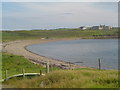
Shingle Beach, Sandwick
Looking across the small shingle beach at Sandwick towards Stoneyfield on Holm Farm.
Image: © Donald Lawson
Taken: 21 Jul 2006
0.08 miles
2
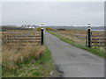
Entrance to Buaile na Cloiche
With newly painted gate posts - they are quite rusty on Street View!
Image: © M J Richardson
Taken: 12 May 2013
0.15 miles
3
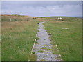
Path to The Iolaire Memorial
Image: © Nick Mutton 01329 000000
Taken: 11 Aug 2009
0.25 miles