IMAGES TAKEN NEAR TO
Lower Sandwick, ISLE OF LEWIS, HS2 0AE
Introduction
This page details the photographs taken nearby to Lower Sandwick, HS2 0AE by members of the Geograph project.
The Geograph project started in 2005 with the aim of publishing, organising and preserving representative images for every square kilometre of Great Britain, Ireland and the Isle of Man.

There are currently over 7.5m images from over14,400 individuals and you can help contribute to the project by visiting https://www.geograph.org.uk
Image Map
Images are licensed for reuse under creativecommons.org/licenses/by-sa/2.0
Notes
- Clicking on the map will re-center to the selected point.
- The higher the marker number, the further away the image location is from the centre of the postcode.
Image Listing (3 Images Found)
Images are licensed for reuse under creativecommons.org/licenses/by-sa/2.0
Image
Details
Distance
1
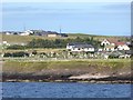
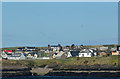
Houses at Lower Sandwick
On the east coast of Cala Steórnabhaigh.
Image: © Oliver Dixon
Taken: 8 Sep 2018
0.22 miles
3
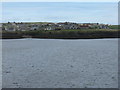
Sanndabhaig from Cala Ste?rnabhagh
Houses at Lower Sandwick seen from the ferry entering the harbour.
Image: © M J Richardson
Taken: 11 May 2013
0.24 miles