IMAGES TAKEN NEAR TO
Urquhart Gardens, STORNOWAY, HS1 2TX
Introduction
This page details the photographs taken nearby to Urquhart Gardens, HS1 2TX by members of the Geograph project.
The Geograph project started in 2005 with the aim of publishing, organising and preserving representative images for every square kilometre of Great Britain, Ireland and the Isle of Man.

There are currently over 7.5m images from over14,400 individuals and you can help contribute to the project by visiting https://www.geograph.org.uk
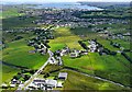
Image Map
Images are licensed for reuse under creativecommons.org/licenses/by-sa/2.0
Notes
- Clicking on the map will re-center to the selected point.
- The higher the marker number, the further away the image location is from the centre of the postcode.
Image Listing (12 Images Found)
Images are licensed for reuse under creativecommons.org/licenses/by-sa/2.0
Image
Details
Distance
1

The Cearns
The Western Isles' largest (and most ugly) housing scheme. The Cearns (courts in English) is a collection of courts named after Scottish islands.
Image: © Donald Lawson
Taken: 21 Jul 2006
0.12 miles
2
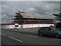
New extension to the Western Isles Hospital
Whilst the roof was being installed there was a problem with too higher wind speed to install the steel sheets on the roof. These two pallets of insulation were on the gable for several days.
Image]
http://www.wihb.scot.nhs.uk/
Image: © John Haynes
Taken: 19 Jul 2010
0.13 miles
3
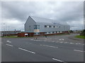
New building at the Western Isles Hospital
New department built in 2010.
Image]
Image: © John Haynes
Taken: 14 Jul 2013
0.13 miles
4
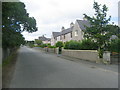
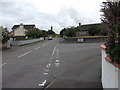
Willowglen Road Stornoway
The two blocks of Terraced Houses were built circa 1938.
Willowglen is the start of the A859 main road from Stornoway to Isle of Harris.
Image: © JJM
Taken: 6 Aug 2005
0.14 miles
5
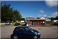
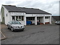
Fusion Takeaway on Willowglen Road, Stornoway
Image: © Ian S
Taken: 21 Jun 2018
0.14 miles
6
The Cearns shop and resource centre
This modern development to the north of Steòrnabhagh is a series of groups of houses with this community shop at its edge.
Image]
Image: © John Haynes
Taken: 11 Jul 2010
0.14 miles
7
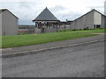
Open space and play area shelter
A shelter in a play area at The Cearns which is a relatively recent extension of Steòrnabhagh.
Image]
Image]
Image: © John Haynes
Taken: 11 Jul 2010
0.15 miles
8
Houses on the northern edge of Ste?rnabhagh
Relatively new houses with big gardens and lots of space all round.
Image: © John Haynes
Taken: 11 Jul 2010
0.19 miles
10
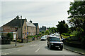
The Road to Stornoway
A view from Laxdale School to Stornoway
Image: © Stephen Branley
Taken: 7 Aug 2008
0.21 miles