IMAGES TAKEN NEAR TO
Bells Road, STORNOWAY, HS1 2RL
Introduction
This page details the photographs taken nearby to Bells Road, HS1 2RL by members of the Geograph project.
The Geograph project started in 2005 with the aim of publishing, organising and preserving representative images for every square kilometre of Great Britain, Ireland and the Isle of Man.

There are currently over 7.5m images from over14,400 individuals and you can help contribute to the project by visiting https://www.geograph.org.uk
Image Map (Loading...)


Getting Data...Please wait
Leaflet Map data © OpenStreetMap
Images are licensed for reuse under creativecommons.org/licenses/by-sa/2.0
Notes
- Clicking on the map will re-center to the selected point.
- The higher the marker number, the further away the image location is from the centre of the postcode.
Image Listing (15 Images Found)
Images are licensed for reuse under creativecommons.org/licenses/by-sa/2.0
Image
Details
Distance
1
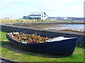
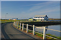
Floral Show, Newton Street
Old boat on Stornoway's waterfront, now in service as a flower tub. In the background is the Coastguard Station.
http://www.stornowaycg.co.uk/
Image: © Colin Smith
Taken: 24 Jul 2011
0.08 miles
2
HM Coastguard, Stornoway
At Battery Point, Stornoway - playing a vital role in maritime rescue around Scotland's coastline.
http://www.stornowaycg.co.uk/
Image: © Colin Smith
Taken: 24 Jul 2011
0.15 miles
3
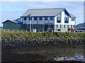
HM Coastguard, Stornoway
A purpose-built Maritime Rescue Co-Ordination Centre (MRCC) opened in 1994 by the Minister of Aviation and Shipping.
Image: © M J Richardson
Taken: 12 May 2013
0.15 miles
4
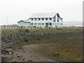
The Coastguard Station
Built around 1993 to replace an aging and cramped operations room situated above the Clydesdale bank in Stornoway town centre. This is viewed from Newton Street.
Image: © Stephen Branley
Taken: 12 Aug 2008
0.16 miles
5
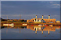
The Coastguard Station
Taken from Goat Island this shows the CG station and, in the background, the power station at Battery Park.
Image: © Stephen Branley
Taken: 15 Aug 2008
0.16 miles
6
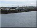
Eilean na Cobhair/Gobhail and Battery Point
Entering harbour on the ferry from Ullapool, the works on the island are on the left of the picture. The building with the communications mast is the Stornoway Coastguard, and the three chimneys belong to the disused power station.
Image: © M J Richardson
Taken: 11 May 2013
0.16 miles
7
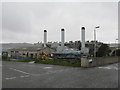
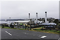
Disused power station at Stornoway
Power is now supplied to Lewis by submarine cable, in addition to its own wind-generated power. The two guns commemorate the establishment on this site at Naclete of the largest RNR battery and training depot in Great Britain. It operated from 1876-1919 and was responsible for the training of thousands of men from Lewis, Harris and Wester Ross. The site was subsequently used as a lookout by HM Coastguard [during which time they were involved in trying to rescue people from 'HMY Iolaire' which was wrecked with the loss of 205 lives. For more details see Image and Image
Image: © M J Richardson
Taken: 12 May 2013
0.16 miles
8
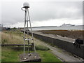
Leica GPS receiver
Leica GPS receiver for the Ordnance Survey stands on a tripod framework by the coast wall. In the background is a visiting cruise ship.
Image: © Mat Tuck
Taken: 29 Aug 2013
0.17 miles
9
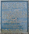
RNR Battery at Naclete Point
Commemorative plaque with details of the history of the site Image
Image: © M J Richardson
Taken: 12 May 2013
0.17 miles