IMAGES TAKEN NEAR TO
Rigs Road, STORNOWAY, HS1 2RF
Introduction
This page details the photographs taken nearby to Rigs Road, HS1 2RF by members of the Geograph project.
The Geograph project started in 2005 with the aim of publishing, organising and preserving representative images for every square kilometre of Great Britain, Ireland and the Isle of Man.

There are currently over 7.5m images from over14,400 individuals and you can help contribute to the project by visiting https://www.geograph.org.uk
Image Map
Images are licensed for reuse under creativecommons.org/licenses/by-sa/2.0
Notes
- Clicking on the map will re-center to the selected point.
- The higher the marker number, the further away the image location is from the centre of the postcode.
Image Listing (33 Images Found)
Images are licensed for reuse under creativecommons.org/licenses/by-sa/2.0
Image
Details
Distance
1
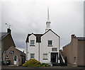
The Church of Jesus Christ of Latter Day Saints
The Church of Jesus Christ of Latter Day Saints, built in 1999, is situated in Newton Street and has a fine view looking over the outer harbour and goat Island. Next door is Isles FM, a volunteer-run community radio station for Scotland's Western Isles, which first broadcast in 1998.
Image: © Stephen Branley
Taken: 20 May 2009
0.11 miles
2
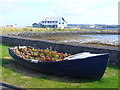
Floral Show, Newton Street
Old boat on Stornoway's waterfront, now in service as a flower tub. In the background is the Coastguard Station.
http://www.stornowaycg.co.uk/
Image: © Colin Smith
Taken: 24 Jul 2011
0.13 miles
3
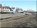
Newton Street, Stornoway
The spire belongs to the Church of Jesus Christ of Latter Day Saints. In the distance is Stornoway Power Station Image
Image: © Oliver Dixon
Taken: 8 Sep 2018
0.13 miles
4
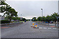
Sandwick Road
Looking along the Sandwick Road with the council offices on the left (a dreadful building architecturally). The village of Sandwick is on this road a mile from here.
Image: © Stephen Branley
Taken: 6 Jul 2008
0.14 miles
5
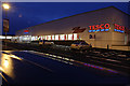
Tesco PLC
Opened in July 2008 this is the 4th supermarket to be opened on this site in the last 20 years and sits to the north of Newton Street.
Image: © Stephen Branley
Taken: 22 Dec 2008
0.15 miles
6
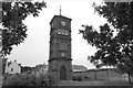
Clock Tower
Built in 1902, this fine tower once had a building joined to it, known as the Clock School. This was demolished it 1972 to make way for the sports centre, the tower was incorporated into the design. That sports centre was demolished in about 2005 and a new one constructed behind the council offices which is out of view to the right. Many people wanted this tower demolished on both occasions but common sense eventually prevailed.
Image: © Stephen Branley
Taken: 6 Jul 2008
0.16 miles
7
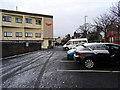
A smattering of snow at Stornoway
By the Caladh Inn.
Image: © John Lucas
Taken: 21 Nov 2015
0.16 miles
8
The Caladh Inn
Formerly known as The Seaforth Hotel, it sits on James Street and was refurbished and revamped in the middle of this decade.
Image: © Stephen Branley
Taken: 19 May 2009
0.17 miles
9
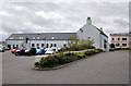
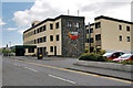
Highlands and Islands Enterprise
Highlands and Islands Enterprise (HIE) is the Scottish Government’s economic and community development agency. The aim of the agency is to build sustainable economic growth in all parts of the Highlands and Islands of Scotland. The building was completely renovated a few years ago and this view of the rear of the building is from James Street, the front runs along Bells Road.
Image: © Stephen Branley
Taken: 19 May 2009
0.17 miles
10
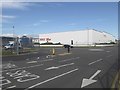
Landfall at Stornoway
The first thing that anyone sees on leaving the ferry terminal is the blank white wall of Tesco's Superstore.
Image: © Oliver Dixon
Taken: 8 Sep 2018
0.17 miles