IMAGES TAKEN NEAR TO
Bramley Close, LEDBURY, HR8 2XP
Introduction
This page details the photographs taken nearby to Bramley Close, HR8 2XP by members of the Geograph project.
The Geograph project started in 2005 with the aim of publishing, organising and preserving representative images for every square kilometre of Great Britain, Ireland and the Isle of Man.

There are currently over 7.5m images from over14,400 individuals and you can help contribute to the project by visiting https://www.geograph.org.uk
Image Map
Images are licensed for reuse under creativecommons.org/licenses/by-sa/2.0
Notes
- Clicking on the map will re-center to the selected point.
- The higher the marker number, the further away the image location is from the centre of the postcode.
Image Listing (4 Images Found)
Images are licensed for reuse under creativecommons.org/licenses/by-sa/2.0
Image
Details
Distance
1
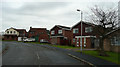
Estate housing in Ledbury
This is Biddulph Way, in the estate known as Deer Park, to the south of the town.
Image: © Jonathan Billinger
Taken: 31 Dec 2007
0.16 miles
3
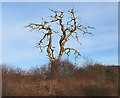
Dead tree alongside the bypass
Unlike the dormant winter trees in the area, this one has lost its smaller twigs. The remaining branches look more like antlers.
Image: © Pauline E
Taken: 12 Jan 2008
0.21 miles
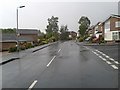
4
Martins Way, Ledbury
From the bypass, Martins Way leads into a modern housing development, south of the town centre.
Image: © Pauline E
Taken: 12 Jan 2008
0.24 miles