IMAGES TAKEN NEAR TO
Lower Eggleton, LEDBURY, HR8 2UJ
Introduction
This page details the photographs taken nearby to HR8 2UJ by members of the Geograph project.
The Geograph project started in 2005 with the aim of publishing, organising and preserving representative images for every square kilometre of Great Britain, Ireland and the Isle of Man.

There are currently over 7.5m images from over14,400 individuals and you can help contribute to the project by visiting https://www.geograph.org.uk
Image Map
Images are licensed for reuse under creativecommons.org/licenses/by-sa/2.0
Notes
- Clicking on the map will re-center to the selected point.
- The higher the marker number, the further away the image location is from the centre of the postcode.
Image Listing (8 Images Found)
Images are licensed for reuse under creativecommons.org/licenses/by-sa/2.0
Image
Details
Distance
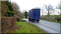
1
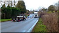
A4103 at Lower Egleton
Roadworks on the Hereford-bound carriageway.
Image: © Jonathan Billinger
Taken: 6 Jan 2015
0.03 miles
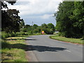
3
A4103 at Lower Egleton
The A4103 Worcester to Hereford road at Lower Egleton.
Image: © Philip Halling
Taken: 31 Mar 2013
0.04 miles
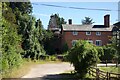
4
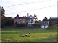
Lower Eggleton Court
Looking south from the A4103 Hereford to Worcester road.
Image: © Bob Embleton
Taken: 4 Jan 2006
0.07 miles
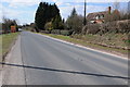
5
A4103, Worcester Road
Pictured at Lower Egleton.
The village name seems to accept spellings with two 'Gs' so take your pick.
Image: © Jonathan Billinger
Taken: 6 Jan 2015
0.07 miles
7
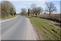
The A4103 at Lower Egleton
This is one of the limited sections of the Hereford to Worcester A4103 where it may be possible to overtake. View eastwards towards Worcester.
Image: © Philip Halling
Taken: 31 Mar 2013
0.13 miles