IMAGES TAKEN NEAR TO
Ashperton, LEDBURY, HR8 2SE
Introduction
This page details the photographs taken nearby to HR8 2SE by members of the Geograph project.
The Geograph project started in 2005 with the aim of publishing, organising and preserving representative images for every square kilometre of Great Britain, Ireland and the Isle of Man.

There are currently over 7.5m images from over14,400 individuals and you can help contribute to the project by visiting https://www.geograph.org.uk
Image Map
Images are licensed for reuse under creativecommons.org/licenses/by-sa/2.0
Notes
- Clicking on the map will re-center to the selected point.
- The higher the marker number, the further away the image location is from the centre of the postcode.
Image Listing (14 Images Found)
Images are licensed for reuse under creativecommons.org/licenses/by-sa/2.0
Image
Details
Distance
3
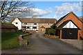
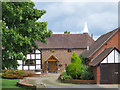
White House Farm
Part timber-framed, part stone built farmhouse at Ashperton. The cowl of a hop kiln can be seen in the background.
Image: © Philip Halling
Taken: 28 Jan 2019
0.16 miles
9
Construction work at Ashperton Primary School
Image: © David Smith
Taken: 22 Apr 2015
0.22 miles
10
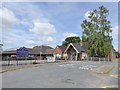
Ashperton primary school
The development work seen in Image is now three years old
Image: © David Smith
Taken: 4 Aug 2018
0.23 miles