IMAGES TAKEN NEAR TO
Woodend, LEDBURY, HR8 2RS
Introduction
This page details the photographs taken nearby to HR8 2RS by members of the Geograph project.
The Geograph project started in 2005 with the aim of publishing, organising and preserving representative images for every square kilometre of Great Britain, Ireland and the Isle of Man.

There are currently over 7.5m images from over14,400 individuals and you can help contribute to the project by visiting https://www.geograph.org.uk
Image Map
Images are licensed for reuse under creativecommons.org/licenses/by-sa/2.0
Notes
- Clicking on the map will re-center to the selected point.
- The higher the marker number, the further away the image location is from the centre of the postcode.
Image Listing (11 Images Found)
Images are licensed for reuse under creativecommons.org/licenses/by-sa/2.0
Image
Details
Distance
4
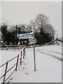
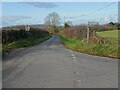
Snowy lane junction
Left to Ashperton.
Image: © Jonathan Billinger
Taken: 23 Jan 2013
0.16 miles
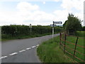
5
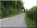
Road junction near Little Tarrington
Road junction near Little Tarrington, the road to the right goes to Asperton.
Image: © Philip Halling
Taken: 22 Nov 2020
0.17 miles
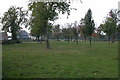
6
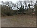
Chicken farm through trees
One of 4 barns in a chicken farm near Ashperton, mostly concealed by trees.
Image: © Pebble
Taken: 6 Mar 2023
0.17 miles
9
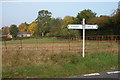
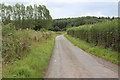
Road junction near Tarrington
Road junction on quiet country lanes between Tarrington and Ashperton.
Image: © Philip Halling
Taken: 15 Oct 2005
0.20 miles
10
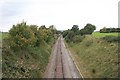
Worcester to Hereford Railway
Looking towards Hereford
Image: © Bob Embleton
Taken: 30 Sep 2007
0.24 miles