IMAGES TAKEN NEAR TO
Falcon Lane, LEDBURY, HR8 2PY
Introduction
This page details the photographs taken nearby to Falcon Lane, HR8 2PY by members of the Geograph project.
The Geograph project started in 2005 with the aim of publishing, organising and preserving representative images for every square kilometre of Great Britain, Ireland and the Isle of Man.

There are currently over 7.5m images from over14,400 individuals and you can help contribute to the project by visiting https://www.geograph.org.uk
Image Map
Images are licensed for reuse under creativecommons.org/licenses/by-sa/2.0
Notes
- Clicking on the map will re-center to the selected point.
- The higher the marker number, the further away the image location is from the centre of the postcode.
Image Listing (14 Images Found)
Images are licensed for reuse under creativecommons.org/licenses/by-sa/2.0
Image
Details
Distance
1
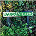
Falcon Lane sign
At the junction with the A438 at Waller's Green.
Image: © Jonathan Billinger
Taken: 16 Oct 2012
0.04 miles
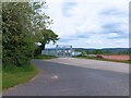
2
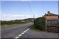
Bus shelter and telephone box, Waller's Green
Image: © David Smith
Taken: 22 Apr 2015
0.05 miles
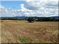
3
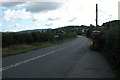
Waller's Green
The A438 passes through Waller's Green about two miles west of Ledbury.
Image: © Philip Halling
Taken: 17 Sep 2005
0.07 miles
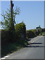
4
Road off Hereford Road (A438)
With a high security entrance.
Image: © JThomas
Taken: 10 Aug 2021
0.08 miles
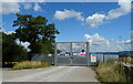
5
Security fence
A high-security fence at the end of a driveway leading to the A438.
Image: © Pebble
Taken: 18 May 2023
0.08 miles
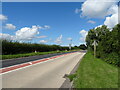
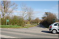
9
Waller's Green
A438 at Waller's Green. Junction with Falcon Lane
Image: © P Gaskell
Taken: Unknown
0.11 miles