IMAGES TAKEN NEAR TO
Preston Cross, LEDBURY, HR8 2LJ
Introduction
This page details the photographs taken nearby to HR8 2LJ by members of the Geograph project.
The Geograph project started in 2005 with the aim of publishing, organising and preserving representative images for every square kilometre of Great Britain, Ireland and the Isle of Man.

There are currently over 7.5m images from over14,400 individuals and you can help contribute to the project by visiting https://www.geograph.org.uk
Image Map
Images are licensed for reuse under creativecommons.org/licenses/by-sa/2.0
Notes
- Clicking on the map will re-center to the selected point.
- The higher the marker number, the further away the image location is from the centre of the postcode.
Image Listing (8 Images Found)
Images are licensed for reuse under creativecommons.org/licenses/by-sa/2.0
Image
Details
Distance
1
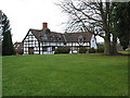
The Veldt House
Business premises of the Velcourt Group - farm management.
Image: © Pauline E
Taken: 2 Dec 2007
0.01 miles
3
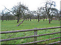
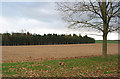
Small orchard near Veldt House
Fruitless and leafless in December gloom.
Image: © Pauline E
Taken: 2 Dec 2007
0.08 miles
4
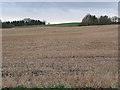
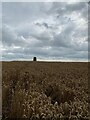
Stubble field near Veldt House
Alive with fieldfares at this time.
Image: © Pauline E
Taken: 2 Dec 2007
0.11 miles
6
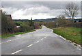
A449 to Ledbury
With a view of the distant Malvern Hills.
Image: © Pauline E
Taken: 15 Jan 2008
0.20 miles
7
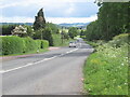
A449 near Much Marcle
A short section of the road visits Gloucestershire. It is one of those once busy A roads that has given up much of its traffic to a motorway. Quite a contrast with the road further north, either side of Kidderminster.
Image: © Richard Webb
Taken: 24 May 2022
0.21 miles
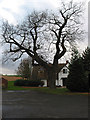
8
Veldt House Trig Point in the middle of a crop field
Image: © thejackrustles
Taken: 5 Aug 2021
0.23 miles