IMAGES TAKEN NEAR TO
Ross Road, LEDBURY, HR8 2LE
Introduction
This page details the photographs taken nearby to Ross Road, HR8 2LE by members of the Geograph project.
The Geograph project started in 2005 with the aim of publishing, organising and preserving representative images for every square kilometre of Great Britain, Ireland and the Isle of Man.

There are currently over 7.5m images from over14,400 individuals and you can help contribute to the project by visiting https://www.geograph.org.uk
Image Map
Images are licensed for reuse under creativecommons.org/licenses/by-sa/2.0
Notes
- Clicking on the map will re-center to the selected point.
- The higher the marker number, the further away the image location is from the centre of the postcode.
Image Listing (6 Images Found)
Images are licensed for reuse under creativecommons.org/licenses/by-sa/2.0
Image
Details
Distance
1
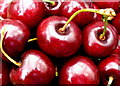
Cherry harvest 2017
One of the leading growers of cherries in the UK is based at Hill House Farm, Ledbury, and they sell directly to the public at their roadside stand.
Image: © Jonathan Billinger
Taken: 15 Jul 2017
0.00 miles
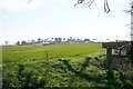
2
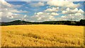
Golden oats; Ledbury skyline, 1
The crop is south-east of Hill House.
Ledbury town with the distinctive spire of St. Michael and All Angels' can be seen nestled below the wooded hills in the distance.
Image: © Jonathan Billinger
Taken: 28 Jul 2013
0.05 miles
3
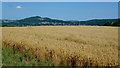
Golden oats; Ledbury skyline, 2
A revisit to this scene four days after Image
Showing what a difference the camera makes!
Image: © Jonathan Billinger
Taken: 1 Aug 2013
0.05 miles
5
Hill House Farm
Viewed from the footpath to Rowland's Green.
Image: © Bob Embleton
Taken: 5 Apr 2007
0.15 miles
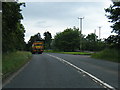
6
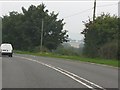
A brief glimpse through the trees
A momentary vista on the A449.
Image: © J Whatley
Taken: 22 Sep 2010
0.20 miles