IMAGES TAKEN NEAR TO
Little Marcle, LEDBURY, HR8 2JX
Introduction
This page details the photographs taken nearby to HR8 2JX by members of the Geograph project.
The Geograph project started in 2005 with the aim of publishing, organising and preserving representative images for every square kilometre of Great Britain, Ireland and the Isle of Man.

There are currently over 7.5m images from over14,400 individuals and you can help contribute to the project by visiting https://www.geograph.org.uk
Image Map
Images are licensed for reuse under creativecommons.org/licenses/by-sa/2.0
Notes
- Clicking on the map will re-center to the selected point.
- The higher the marker number, the further away the image location is from the centre of the postcode.
Image Listing (7 Images Found)
Images are licensed for reuse under creativecommons.org/licenses/by-sa/2.0
Image
Details
Distance
1
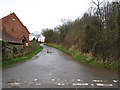
Country road to Waller's Green
Near Upper House and with a small wooded area on the right.
Image: © Pauline E
Taken: 15 Jan 2008
0.09 miles
2
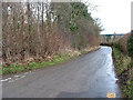
Wooded area by country road in winter
Looking towards Ledbury.
Image: © Pauline E
Taken: 15 Jan 2008
0.11 miles
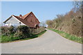
5
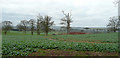
Arable fields at Putson
View west towards Marcle Ridge in the distance.
Image: © Jonathan Billinger
Taken: 31 Dec 2007
0.18 miles
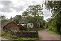
6
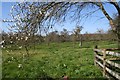
Orchard near "Overseas"
On the footpath towards Putson Coppice.
Image: © Bob Embleton
Taken: 5 Apr 2007
0.18 miles
7

Oak tree in a hedgerow
East of Baregains Lane, Herefordshire.
Image: © Jonathan Billinger
Taken: 30 Apr 2014
0.24 miles