IMAGES TAKEN NEAR TO
Donnington, LEDBURY, HR8 2HZ
Introduction
This page details the photographs taken nearby to HR8 2HZ by members of the Geograph project.
The Geograph project started in 2005 with the aim of publishing, organising and preserving representative images for every square kilometre of Great Britain, Ireland and the Isle of Man.

There are currently over 7.5m images from over14,400 individuals and you can help contribute to the project by visiting https://www.geograph.org.uk
Image Map
Images are licensed for reuse under creativecommons.org/licenses/by-sa/2.0
Notes
- Clicking on the map will re-center to the selected point.
- The higher the marker number, the further away the image location is from the centre of the postcode.
Image Listing (7 Images Found)
Images are licensed for reuse under creativecommons.org/licenses/by-sa/2.0
Image
Details
Distance
1
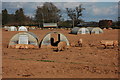
Pigs at Bromesberrow Heath
Free running pigs in a field to the west of Bromesberrow Heath.
Image: © Philip Halling
Taken: 4 Apr 2008
0.12 miles
3
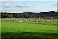
A field of pigs
A field of pigs complete with their pig huts near Broom's Green.
Image: © Philip Halling
Taken: 22 Oct 2020
0.16 miles
6
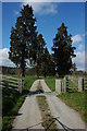
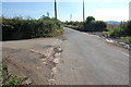
Entrance to Haffield, near Donnington
An avenue of Wellingtonia trees line the entrance to the early nineteenth century country house called Haffield. These trees can be seen from the M50 which passes a mill or so to the south.
Image: © Philip Halling
Taken: 4 Apr 2008
0.21 miles
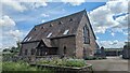
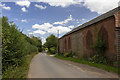
7
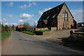
Former School, Bromesberrow Heath
Former school in Bromesberrow, near converted into a residential home.
Image: © Philip Halling
Taken: 4 Apr 2008
0.22 miles