IMAGES TAKEN NEAR TO
Dymock Road, LEDBURY, HR8 2HU
Introduction
This page details the photographs taken nearby to Dymock Road, HR8 2HU by members of the Geograph project.
The Geograph project started in 2005 with the aim of publishing, organising and preserving representative images for every square kilometre of Great Britain, Ireland and the Isle of Man.

There are currently over 7.5m images from over14,400 individuals and you can help contribute to the project by visiting https://www.geograph.org.uk
Image Map
Images are licensed for reuse under creativecommons.org/licenses/by-sa/2.0
Notes
- Clicking on the map will re-center to the selected point.
- The higher the marker number, the further away the image location is from the centre of the postcode.
Image Listing (6 Images Found)
Images are licensed for reuse under creativecommons.org/licenses/by-sa/2.0
Image
Details
Distance
1
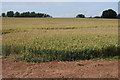
Field of wheat
A field of wheat opposite Highbridge Farm beside the B4216 to the south of Ledbury.
Image: © Philip Halling
Taken: 14 Jul 2011
0.17 miles
2
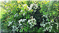
May blossom, Cretaegus sp
At its peak of scent and whiteness in late May.
Image: © Jonathan Billinger
Taken: 27 May 2021
0.18 miles
3
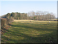
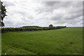
Pasture and small wood north of Argus Farm
Image: © Pauline E
Taken: 18 Feb 2008
0.19 miles
4
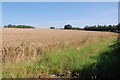
Crop Field off B4216
Near Argus Farm.
Image: © Julian P Guffogg
Taken: 10 Aug 2012
0.20 miles
5
Hedgerows at Argus Farm
Hedgerows and temporary grass at Argus Farm
Image: © P Gaskell
Taken: Unknown
0.21 miles
6
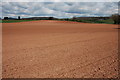
Ploughed field near Donnington
Ploughed field viewed from the footpath from Donnington to Parkway near Ledbury.
Image: © Philip Halling
Taken: 4 Apr 2008
0.22 miles