IMAGES TAKEN NEAR TO
Eastnor, LEDBURY, HR8 1RG
Introduction
This page details the photographs taken nearby to HR8 1RG by members of the Geograph project.
The Geograph project started in 2005 with the aim of publishing, organising and preserving representative images for every square kilometre of Great Britain, Ireland and the Isle of Man.

There are currently over 7.5m images from over14,400 individuals and you can help contribute to the project by visiting https://www.geograph.org.uk
Image Map
Images are licensed for reuse under creativecommons.org/licenses/by-sa/2.0
Notes
- Clicking on the map will re-center to the selected point.
- The higher the marker number, the further away the image location is from the centre of the postcode.
Image Listing (8 Images Found)
Images are licensed for reuse under creativecommons.org/licenses/by-sa/2.0
Image
Details
Distance
2
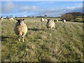
Sheep on Howler's Heath
View eastwards with High Wood on the right.
Image: © Trevor Rickard
Taken: 3 Dec 2007
0.16 miles
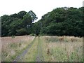
3
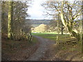
Track to Hillend Farm
Looking north-west as the track leaves Howler's Coppice. The track leads left to Hillend farm, the public footpath turns to the right.
Image: © Trevor Rickard
Taken: 3 Dec 2007
0.16 miles
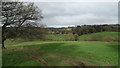
4
Eastnor Castle
Eastnor Castle viewed from the south-east.
Image: © Philip Halling
Taken: 1 Jan 2007
0.19 miles
5
Toney's Coppice, Howler's Heath
Looking north on the track from Toney's Farm to Wayend Street
Image: © Bob Embleton
Taken: 31 Jul 2005
0.20 miles
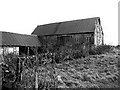
6
Howler's Coppice
The southern boundary of Howler's Coppice.
Image: © Philip Halling
Taken: 1 Jan 2007
0.20 miles
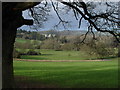
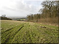
7

View to High Wood
The hedge on the field boundary is the county boundary between Herefordshire on this side and Gloucestershire on the other side.
Image: © Philip Halling
Taken: 4 Dec 2021
0.21 miles
8
View towards Wayend Street from Locust Coppice
A un-defined path crosses this field.
Image: © Colin Park
Taken: 4 Feb 2020
0.22 miles