IMAGES TAKEN NEAR TO
Upper Road, LEDBURY, HR8 1RB
Introduction
This page details the photographs taken nearby to Upper Road, HR8 1RB by members of the Geograph project.
The Geograph project started in 2005 with the aim of publishing, organising and preserving representative images for every square kilometre of Great Britain, Ireland and the Isle of Man.

There are currently over 7.5m images from over14,400 individuals and you can help contribute to the project by visiting https://www.geograph.org.uk
Image Map
Images are licensed for reuse under creativecommons.org/licenses/by-sa/2.0
Notes
- Clicking on the map will re-center to the selected point.
- The higher the marker number, the further away the image location is from the centre of the postcode.
Image Listing (166 Images Found)
Images are licensed for reuse under creativecommons.org/licenses/by-sa/2.0
Image
Details
Distance
1
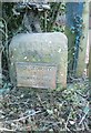
Old Milestone by the A438, Eastnor
Metal plate attached to stone post by the A438, in parish of EASTNOR (District), just South of turn to village, under hedge, by gate to house. Ledbury stone, erected by the Ledbury turnpike trust in the 19th century.
Inscription on stone reads:-
TO
LEDBURY
2
Inscription on plate reads:-
TO
LEDBURY
2
TEWKESBURY
12
Grade II listed. List Entry Number: 1082592
https://historicengland.org.uk/listing/the-list/list-entry/1082592
Milestone Society National ID: HF_LBTK02.
Image: © J Scrine
Taken: 10 Apr 2010
0.03 miles
2
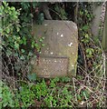
Listed milestone on the A438
Mid-C19. Incised lettering reads: "TO/ LEDBURY/ 2". There is a cast iron plate affixed over lower part with lettering which reads: "TO LEDBURY/ 2/ TEWKESBURY/ 12". This is part of a complete group of milestones in the Ledbury area.
Image: © Eirian Evans
Taken: 12 Aug 2017
0.03 miles
4
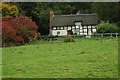
Thatched cottage at Eastnor
Attractive thatched cottage in Eastnor.
Image: © Philip Halling
Taken: 25 Oct 2008
0.05 miles
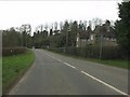
5
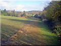
Public footpath at Eastnor
Heading east near the churchyard, which is just over the hedge on the right. Eastnor Park on the hillside opposite and in the distance on the left is the Herefordshire Beacon, part of the Malvern Hills.
Image: © Trevor Rickard
Taken: 17 Nov 2009
0.06 miles
6
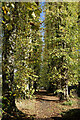
A Tall Avenue
A short footpath between Eastnor Church and the main road goes between tall poplar trees.
Image: © Des Blenkinsopp
Taken: 2 Nov 2021
0.08 miles
7
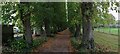
Footpath avenue
An avenue with a public footpath (the Geopark Way) leading away from the church and towards Eastnor's Deer Park.
Image: © Pebble
Taken: 10 Oct 2020
0.08 miles
8
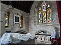
St. John the Baptist church (Mortuary chapel | Eastnor)
The mortuary chapel inside Eastnor parish church had a grim atmosphere that made me not look around it for long. There were many bat droppings on the tomb effigy to Charles Somers-Cocks, 3rd Earl Somers (1819-83), and it has been covered up since Philip Halling took a photograph of the effigy in 2019 Image
Image: © Fabian Musto
Taken: 15 Jul 2022
0.08 miles
9
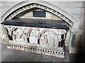
Tomb inside St. John the Baptist church (Eastnor)
This tomb is situated in the east end of the mortuary chapel at Eastnor parish church.
Image: © Fabian Musto
Taken: 15 Jul 2022
0.08 miles
10
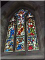
Window inside St. John the Baptist church (Mortuary chapel | Eastnor)
This three-light stained-glass window is situated in the east end of the mortuary chapel.
Image: © Fabian Musto
Taken: 15 Jul 2022
0.08 miles