IMAGES TAKEN NEAR TO
Aylescroft, LEDBURY, HR8 1QA
Introduction
This page details the photographs taken nearby to Aylescroft, HR8 1QA by members of the Geograph project.
The Geograph project started in 2005 with the aim of publishing, organising and preserving representative images for every square kilometre of Great Britain, Ireland and the Isle of Man.

There are currently over 7.5m images from over14,400 individuals and you can help contribute to the project by visiting https://www.geograph.org.uk
Image Map
Images are licensed for reuse under creativecommons.org/licenses/by-sa/2.0
Notes
- Clicking on the map will re-center to the selected point.
- The higher the marker number, the further away the image location is from the centre of the postcode.
Image Listing (12 Images Found)
Images are licensed for reuse under creativecommons.org/licenses/by-sa/2.0
Image
Details
Distance
1
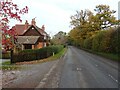
House near Bosbury
House beside the B4220 to the east of the village of Bosbury.
Image: © Philip Halling
Taken: 7 Nov 2020
0.01 miles
2
The B4220 near Bosbury
The B4220 near Bosbury, at its junction with a minor road from Wellington Heath.
Image: © Philip Halling
Taken: 7 Nov 2020
0.11 miles
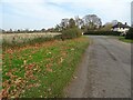
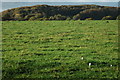
3
Field near Bosbury
A field beside the B4220 just outside the village of Bosbury.
Image: © Philip Halling
Taken: 7 Nov 2020
0.13 miles
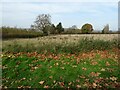
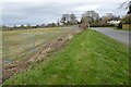
4
Building land at Bosbury
This field is fenced off with Heras fencing in preparation for development.
Image: © Philip Halling
Taken: 17 Mar 2022
0.13 miles
5
Building land at Bosbury
This field is fenced off with Heras fencing in preparation for development.
Image: © Philip Halling
Taken: 17 Mar 2022
0.13 miles
6
Beacon Hill viewed from the south-east
The wooded Beacon Hill viewed from the south-east, spot the toadstools in the foreground.
Image: © Philip Halling
Taken: 24 Oct 2009
0.14 miles
7
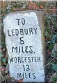
Old Milestone by the B4220, Ailscroft, Bosbury parish
Carved stone post by the B4220, in parish of BOSBURY (District), Ailscroft, by hedge, at corner near chevrons, on East side of road. Ledbury stone, erected by the Ledbury turnpike trust in the 19th century.
Inscription reads:-
TO
LEDBURY
5
MILES
WORCESTER
13
MILES
Grade II listed.
List Entry Number: 1098923 https://historicengland.org.uk/listing/the-list/list-entry/1098923
Milestone Society National ID: HF_LBWO05.
Image: © Robert Walker
Taken: 3 Mar 2012
0.16 miles
8
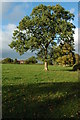
Tree opposite Bosbury House
Tree and house opposite Bosbury House.
Image: © Philip Halling
Taken: 24 Oct 2009
0.18 miles
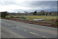
9
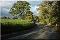
The B4220 near Bosbury
The B4220 near Bosbury House to the east of Bosbury.
Image: © Philip Halling
Taken: 24 Oct 2009
0.18 miles
10
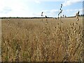
A field of oats
A field of oats near Bosbury.
Image: © Philip Halling
Taken: 23 Aug 2021
0.24 miles