IMAGES TAKEN NEAR TO
Bromsberrow Heath, LEDBURY, HR8 1PA
Introduction
This page details the photographs taken nearby to HR8 1PA by members of the Geograph project.
The Geograph project started in 2005 with the aim of publishing, organising and preserving representative images for every square kilometre of Great Britain, Ireland and the Isle of Man.

There are currently over 7.5m images from over14,400 individuals and you can help contribute to the project by visiting https://www.geograph.org.uk
Image Map
Images are licensed for reuse under creativecommons.org/licenses/by-sa/2.0
Notes
- Clicking on the map will re-center to the selected point.
- The higher the marker number, the further away the image location is from the centre of the postcode.
Image Listing (13 Images Found)
Images are licensed for reuse under creativecommons.org/licenses/by-sa/2.0
Image
Details
Distance
1
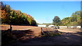
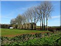
Russell's End Farm
A business engaged in arboriculture.
Image: © Jonathan Billinger
Taken: 20 Oct 2015
0.07 miles
4
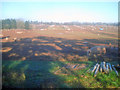
Arboriculture near Russell's End Farm
Arboriculture; mainly seedling trees and shrubs for landscaping and hedgerow purposes.
These will be lifted and sold for transplanting in the winter as bare-root plants, hence there has been a bit of recent activity here.
The soil is quite sandy; hence the names with 'heath' locally, thus making the land ideal for this type of horticulture.
Image: © Jonathan Billinger
Taken: 11 Feb 2015
0.15 miles
5
Bare trees
December 1st and all the leaves have fallen from these trees in a hedgerow near Bromesberrow Heath.
Image: © Philip Halling
Taken: 1 Dec 2020
0.16 miles
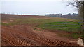
6
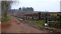
Track to Russell's End Farm
Land-use hereabouts is arboriculture.
Mainly seedling trees and shrubs for landscaping and hedgerow purposes.
These will be lifted and sold for transplanting in the winter as bare-root plants, hence there has been a bit of recent activity here.
The soil is quite sandy; hence the names with 'heath' locally, thus making the land ideal for this type of horticulture.
Image: © Jonathan Billinger
Taken: 11 Feb 2015
0.17 miles
7
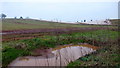
Pig farm near Russell's End - 3
Looking north from the lane. The pig in the foreground is eating concentrates from a dispenser which it operates by nosing a bar at the bottom. Not much grass left at this end of the field.
Image: © Trevor Rickard
Taken: 1 Jan 2010
0.19 miles
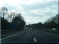
8
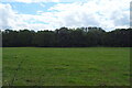
Grazing and woodland, Russell's End
Towards the M50 Motorway.
Image: © JThomas
Taken: 10 Aug 2021
0.20 miles
9
Fruit-growing near Lintridge Farm
The crop under the low polythene cloches would be strawberries.
Update October 2015; I now learn that the crop in these fields is a range of native hedging plants for the amenity industry.
Image: © Jonathan Billinger
Taken: 11 Feb 2015
0.22 miles
10
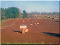
Pig farm near Russell's End - 1
Looking north across a large area of pig pens surrounded by electric fences. Still some grass in evidence, which suggests that they have not been here too long. Only a matter of time before this whole area has been nosed over.
Image: © Trevor Rickard
Taken: 1 Jan 2010
0.22 miles