IMAGES TAKEN NEAR TO
Bosbury, LEDBURY, HR8 1NW
Introduction
This page details the photographs taken nearby to HR8 1NW by members of the Geograph project.
The Geograph project started in 2005 with the aim of publishing, organising and preserving representative images for every square kilometre of Great Britain, Ireland and the Isle of Man.

There are currently over 7.5m images from over14,400 individuals and you can help contribute to the project by visiting https://www.geograph.org.uk
Image Map
Images are licensed for reuse under creativecommons.org/licenses/by-sa/2.0
Notes
- Clicking on the map will re-center to the selected point.
- The higher the marker number, the further away the image location is from the centre of the postcode.
Image Listing (4 Images Found)
Images are licensed for reuse under creativecommons.org/licenses/by-sa/2.0
Image
Details
Distance
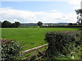
1
The farm Bosbury
Grade II Listed early 19th century farmhouse. In 1911 the farm is listed as having the Farmer, his wife and son plus a shepherd, domestic cook and housemaid. Now Registered office of Hawkins Farming Ltd. and the home of Sarah's Cider who claim that the cider cellar dates back to the 18th century on its website. The Farm is also a major producer of English Aromatic Hops and has an award winning “Bosa” herd of Hereford Cattle (is that them I spy in the foreground?).
Image: © Jo and Steve Turner
Taken: 25 May 1997
0.01 miles
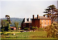
2
Farmland east of the Bromyard Road
Distant view to the Malvern Hills; the farm to the right, in SO6942, is simply named The Farm.
Image: © Jonathan Billinger
Taken: 14 Nov 2014
0.17 miles
3
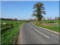
The B4214 north of Staplow
Tree beside the B4214 between Ledbury and Bosbury.
Image: © Philip Halling
Taken: 2 Apr 2021
0.23 miles