IMAGES TAKEN NEAR TO
Staplow, LEDBURY, HR8 1NR
Introduction
This page details the photographs taken nearby to HR8 1NR by members of the Geograph project.
The Geograph project started in 2005 with the aim of publishing, organising and preserving representative images for every square kilometre of Great Britain, Ireland and the Isle of Man.

There are currently over 7.5m images from over14,400 individuals and you can help contribute to the project by visiting https://www.geograph.org.uk
Image Map
Images are licensed for reuse under creativecommons.org/licenses/by-sa/2.0
Notes
- Clicking on the map will re-center to the selected point.
- The higher the marker number, the further away the image location is from the centre of the postcode.
Image Listing (6 Images Found)
Images are licensed for reuse under creativecommons.org/licenses/by-sa/2.0
Image
Details
Distance
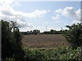

3

Baregains, near Munsley
Red-brick farm building at Baregains Farm near Munsley.
Image: © Philip Halling
Taken: 22 Oct 2005
0.17 miles
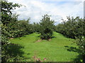
6
Orchards west of Jug's Green
Older apples here; probably eating, not cider, judging by the spacing.
Image: © Jonathan Billinger
Taken: 23 Jul 2008
0.24 miles