IMAGES TAKEN NEAR TO
Frith Lane, LEDBURY, HR8 1LW
Introduction
This page details the photographs taken nearby to Frith Lane, HR8 1LW by members of the Geograph project.
The Geograph project started in 2005 with the aim of publishing, organising and preserving representative images for every square kilometre of Great Britain, Ireland and the Isle of Man.

There are currently over 7.5m images from over14,400 individuals and you can help contribute to the project by visiting https://www.geograph.org.uk
Image Map
Images are licensed for reuse under creativecommons.org/licenses/by-sa/2.0
Notes
- Clicking on the map will re-center to the selected point.
- The higher the marker number, the further away the image location is from the centre of the postcode.
Image Listing (18 Images Found)
Images are licensed for reuse under creativecommons.org/licenses/by-sa/2.0
Image
Details
Distance
5
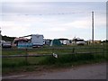
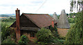
Frith Farm Camp Site
Part of Wye Valley Fruit Farms
Image: © Bob Embleton
Taken: 20 Jul 2005
0.07 miles
8
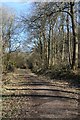
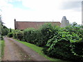
Woodland track
Woodland track in Frith Wood.
Image: © Philip Halling
Taken: 26 Mar 2018
0.13 miles
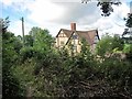
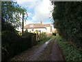
9
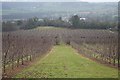
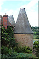
Tyre Orchard ?
Orchard near Frith Farm house. One possibility for the tyres could be to provide shelter for beneficial insects.
Image: © Bob Embleton
Taken: 18 Feb 2007
0.15 miles
10
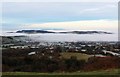
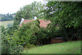
Frith Wood in the freezing fog
The ridge north of Ledbury standing proud of the sea of fog.
Viewed from the Malvern Hills.
Image: © Bob Embleton
Taken: 25 Nov 2014
0.16 miles