IMAGES TAKEN NEAR TO
Bosbury, LEDBURY, HR8 1JX
Introduction
This page details the photographs taken nearby to HR8 1JX by members of the Geograph project.
The Geograph project started in 2005 with the aim of publishing, organising and preserving representative images for every square kilometre of Great Britain, Ireland and the Isle of Man.

There are currently over 7.5m images from over14,400 individuals and you can help contribute to the project by visiting https://www.geograph.org.uk
Image Map
Images are licensed for reuse under creativecommons.org/licenses/by-sa/2.0
Notes
- Clicking on the map will re-center to the selected point.
- The higher the marker number, the further away the image location is from the centre of the postcode.
Image Listing (9 Images Found)
Images are licensed for reuse under creativecommons.org/licenses/by-sa/2.0
Image
Details
Distance
1
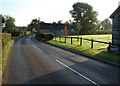
B4220 at Norbridge
The road passes Palace Farm and Hill Park Farm in the morning sun.
Image: © Derek Harper
Taken: 13 Sep 2008
0.03 miles
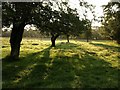
2
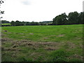
Orchard, Norbridge
A view in the opposite direction from Image, with Palace Farm across the rather empty orchard. The oak on the right is one of a row showing that this was formerly two orchards. The early morning sun seems to lend a painting-like quality.
Image: © Derek Harper
Taken: 13 Sep 2008
0.08 miles
3
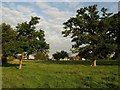
Line of oaks, Norbridge
This line of trees clearly runs along a former field boundary, as mentioned in Image
Image: © Derek Harper
Taken: 13 Sep 2008
0.09 miles
4
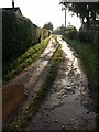
Track, Norbridge
Leading away from the B4220, this track is followed by the footpath to Moorend Cross.
Image: © Derek Harper
Taken: 13 Sep 2008
0.11 miles
5
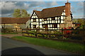
Norbridge Farm
Another view of the timbered farm shown in Image, beside the B4220.
Image: © Derek Harper
Taken: 13 Sep 2008
0.11 miles
6
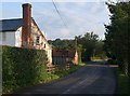
Timber-framed house, Old Country
An attractive timber-framed house at Old Country near Coddington.
Image: © Philip Halling
Taken: 24 Oct 2009
0.12 miles
8
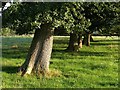
Orchard, Norbridge
In fact, these trees represent the scant remains of the orchard shown on the 1:25000 map. The path to Old Country Farm passes them.
Image: © Derek Harper
Taken: 13 Sep 2008
0.14 miles