IMAGES TAKEN NEAR TO
Fromes Hill, LEDBURY, HR8 1HW
Introduction
This page details the photographs taken nearby to HR8 1HW by members of the Geograph project.
The Geograph project started in 2005 with the aim of publishing, organising and preserving representative images for every square kilometre of Great Britain, Ireland and the Isle of Man.

There are currently over 7.5m images from over14,400 individuals and you can help contribute to the project by visiting https://www.geograph.org.uk
Image Map
Images are licensed for reuse under creativecommons.org/licenses/by-sa/2.0
Notes
- Clicking on the map will re-center to the selected point.
- The higher the marker number, the further away the image location is from the centre of the postcode.
Image Listing (9 Images Found)
Images are licensed for reuse under creativecommons.org/licenses/by-sa/2.0
Image
Details
Distance
1
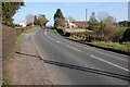
The A4103 at Fromes Hill
The A4103, Hereford to Worcester road at Fromes Hill.
Image: © Philip Halling
Taken: 11 Mar 2012
0.09 miles
2
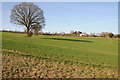
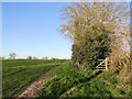
Herefordshire Trail at Fromes Hill
The Herefordshire Trail crossing an arable field at Fromes Hill, the line of tree suggest there may have once been a hedgerow splitting this into a smaller field.
Image: © Philip Halling
Taken: 11 Mar 2012
0.10 miles
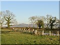
5
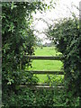
Overgrown stile
Effectively impassable due to the quantity of brambles.
Image: © Peter Whatley
Taken: 22 Jul 2008
0.20 miles
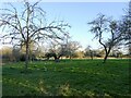
7
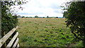
One field footpath
A short straight path across this grazing land to the main road at Frome's Hill.
Image: © Jonathan Billinger
Taken: 10 Aug 2015
0.21 miles
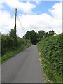
8
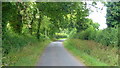
Lane to Halmond's Frome
Heading north along the crest of Frome's Hill.
Image: © Jonathan Billinger
Taken: 10 Aug 2015
0.21 miles