IMAGES TAKEN NEAR TO
Fromes Hill, LEDBURY, HR8 1HU
Introduction
This page details the photographs taken nearby to HR8 1HU by members of the Geograph project.
The Geograph project started in 2005 with the aim of publishing, organising and preserving representative images for every square kilometre of Great Britain, Ireland and the Isle of Man.

There are currently over 7.5m images from over14,400 individuals and you can help contribute to the project by visiting https://www.geograph.org.uk
Image Map
Images are licensed for reuse under creativecommons.org/licenses/by-sa/2.0
Notes
- Clicking on the map will re-center to the selected point.
- The higher the marker number, the further away the image location is from the centre of the postcode.
Image Listing (8 Images Found)
Images are licensed for reuse under creativecommons.org/licenses/by-sa/2.0
Image
Details
Distance
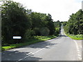
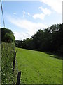
1
View towards a cottage at Steen's Bridge
Image: © Jonathan Thacker
Taken: 19 Sep 2016
0.01 miles
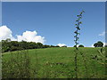
5
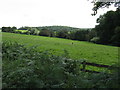
Lone sheep
Baa-ly No-mates in a field opposite the A4103's Evesbatch junction.
Image: © Peter Whatley
Taken: 2 Sep 2008
0.13 miles
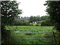
6
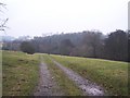
Track to Collier's Mill and Dodd's Mill
Looking south down what must have been an important old road in the past from close to Speen's Bridge.
Image: © Bob Embleton
Taken: 6 Jan 2006
0.15 miles
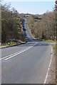
7
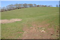
Merrell's Wood
View to Merrell's Wood near Evesbatch.
Image: © Philip Halling
Taken: 11 Mar 2012
0.16 miles