IMAGES TAKEN NEAR TO
Massington, LEDBURY, HR8 1EQ
Introduction
This page details the photographs taken nearby to HR8 1EQ by members of the Geograph project.
The Geograph project started in 2005 with the aim of publishing, organising and preserving representative images for every square kilometre of Great Britain, Ireland and the Isle of Man.

There are currently over 7.5m images from over14,400 individuals and you can help contribute to the project by visiting https://www.geograph.org.uk
Image Map
Images are licensed for reuse under creativecommons.org/licenses/by-sa/2.0
Notes
- Clicking on the map will re-center to the selected point.
- The higher the marker number, the further away the image location is from the centre of the postcode.
Image Listing (6 Images Found)
Images are licensed for reuse under creativecommons.org/licenses/by-sa/2.0
Image
Details
Distance
1
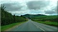
Approaching bends warning signs on A449
This straight stretch is followed by a series of bends after the Wellington Inn (visible in middle of image). Herefordshire Beacon is the more distant hill.
Image: © Clint Mann
Taken: 18 Jul 2016
0.11 miles
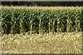
5
Partially harvested maize
Partially harvested maize in a field near Colwall.
Image: © Philip Halling
Taken: 1 Oct 2021
0.19 miles
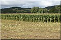
6
A maize crop
A partially harvested field of maize near Colwall.
Image: © Philip Halling
Taken: 1 Oct 2021
0.19 miles