IMAGES TAKEN NEAR TO
Callow End, LEDBURY, HR8 1BG
Introduction
This page details the photographs taken nearby to Callow End, HR8 1BG by members of the Geograph project.
The Geograph project started in 2005 with the aim of publishing, organising and preserving representative images for every square kilometre of Great Britain, Ireland and the Isle of Man.

There are currently over 7.5m images from over14,400 individuals and you can help contribute to the project by visiting https://www.geograph.org.uk
Image Map
Images are licensed for reuse under creativecommons.org/licenses/by-sa/2.0
Notes
- Clicking on the map will re-center to the selected point.
- The higher the marker number, the further away the image location is from the centre of the postcode.
Image Listing (124 Images Found)
Images are licensed for reuse under creativecommons.org/licenses/by-sa/2.0
Image
Details
Distance
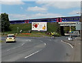
1
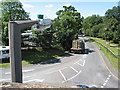
Hereford Rd, A438, from the railway station, Ledbury
Image: © Pauline E
Taken: 31 Jul 2007
0.02 miles
2
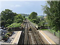
Site of Ledbury Junction
A branch line from Ledbury to Gloucester used to leave the main Hereford line on the left immediately beyond the road bridge at the platform ends. The embankment can still just be seen. The line was a classic country branch, moribund by the 1930s and propped up latterly by post-war restrictions on travel. It was finally put out of its misery in July 1959, failing to survive even until the Beeching era.
Image: © Peter Whatley
Taken: 2 Sep 2008
0.03 miles
3
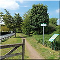
Ledbury Town Trail
This part of the trail is on the north side of the A438 Hereford Road, viewed from near the B4214 Bromyard Road junction.
Image: © Jaggery
Taken: 19 May 2013
0.03 miles
4
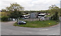
Smiths of Ledbury
The garage of the family-run Ledbury-based coach hire company
is on the corner of The Homend and Hereford Road.
Image: © Jaggery
Taken: 19 May 2013
0.03 miles
5
Train on an embankment in Ledbury
A First Great Western train heads west towards Hereford away from Ledbury railway station,
which is located at the northern edge of town. The car and cyclist are entering Hereford Road.
Image: © Jaggery
Taken: 19 May 2013
0.04 miles
6
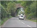
Ledbury - former Gloucester branch bridge
The railway line between Ledbury and Gloucester was a classic country branch line, in this instance replacing a failed canal (1790-1838). It was moribund before World War II, with the then owners actively encouraging passengers to use alternative bus services! The line limped on until 1959 at which point the Ledbury-Dymock section was closed completely, the Dymock-Gloucester section surviving for intermittent freight traffic until 1964.
Image: © J Whatley
Taken: 22 Sep 2010
0.04 miles
7
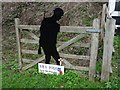
Lest We Forget
Lest We Forget 1914-1918, one of many of these memorials around the country marking the centenary of the end of the Great War (WWI).
Image: © Philip Halling
Taken: 2 Jan 2019
0.04 miles
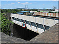
9
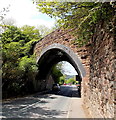
Skewed bridge across Hereford Road, Ledbury
The former railway bridge, now part of the Ledbury Town Trail, crosses Hereford Road diagonally.
http://www.geograph.org.uk/photo/3846706 to a closer view.
Image: © Jaggery
Taken: 19 May 2013
0.05 miles
10
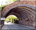
Skewed bridge detail, Hereford Road, Ledbury
A view of the underside of this http://www.geograph.org.uk/photo/3846697 bridge.
Image: © Jaggery
Taken: 19 May 2013
0.05 miles