IMAGES TAKEN NEAR TO
Winslow Road, BROMYARD, HR7 4UA
Introduction
This page details the photographs taken nearby to Winslow Road, HR7 4UA by members of the Geograph project.
The Geograph project started in 2005 with the aim of publishing, organising and preserving representative images for every square kilometre of Great Britain, Ireland and the Isle of Man.

There are currently over 7.5m images from over14,400 individuals and you can help contribute to the project by visiting https://www.geograph.org.uk
Image Map
Images are licensed for reuse under creativecommons.org/licenses/by-sa/2.0
Notes
- Clicking on the map will re-center to the selected point.
- The higher the marker number, the further away the image location is from the centre of the postcode.
Image Listing (18 Images Found)
Images are licensed for reuse under creativecommons.org/licenses/by-sa/2.0
Image
Details
Distance
1
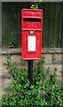
Elizabeth II postbox on Old Road, Bromyard
Postbox No. HR7 437.
Image: © JThomas
Taken: 11 Aug 2021
0.17 miles
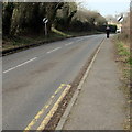
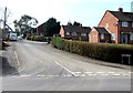
2
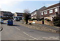
Winslow Road, Bromyard
Viewed across Tenbury Road.
Image: © Jaggery
Taken: 19 Mar 2015
0.18 miles
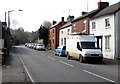
3
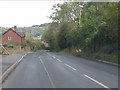
Old Road vista
Bromyard Downs on the far side of the From valley forms the backdrop.
Image: © Peter Whatley
Taken: 25 Oct 2011
0.19 miles
4
Awaiting development
House construction authorised on the site on the right is on hold for the foreseeable future.
Image: © Peter Whatley
Taken: 25 Oct 2011
0.19 miles
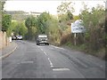
5
End of the 30 zone at the northern edge of Bromyard
The 30mph speed limit on the B4214 Tenbury Road increases to the National Speed Limit ahead.
Image: © Jaggery
Taken: 19 Mar 2015
0.20 miles
6
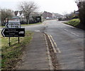
Turn left for two industrial estates in Bromyard
The sign for Porthouse industrial estate and Station industrial estate
is alongside the B4214 Tenbury Road at the northern edge of Bromyard.
Image: © Jaggery
Taken: 19 Mar 2015
0.21 miles
7
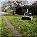
Two metal spheres on a base, Bromyard
Located near the junction of Tenbury Road and the entrance road to Porthouse Industrial Estate.
In March 2015, there is no plaque nor anything else here to explain what is being depicted.
Image: © Jaggery
Taken: 19 Mar 2015
0.21 miles
8
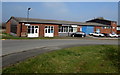
King Edward, Bromyard
Catering equipment business in Porthouse Industrial Estate.
Image: © Jaggery
Taken: 19 Mar 2015
0.22 miles
9
Ballhurst, Bromyard
Viewed across Tenbury Road. Some maps show Ballhurst Road,
but the street name sign (and local estate agents) disagree.
Image: © Jaggery
Taken: 19 Mar 2015
0.23 miles
10
Old Road, Bromyard
The B4214 Old Road heads away from the junction with Cruxwell Street and Tenbury Road.
Image: © Jaggery
Taken: 19 Mar 2015
0.23 miles