IMAGES TAKEN NEAR TO
Pencombe, BROMYARD, HR7 4SQ
Introduction
This page details the photographs taken nearby to HR7 4SQ by members of the Geograph project.
The Geograph project started in 2005 with the aim of publishing, organising and preserving representative images for every square kilometre of Great Britain, Ireland and the Isle of Man.

There are currently over 7.5m images from over14,400 individuals and you can help contribute to the project by visiting https://www.geograph.org.uk
Image Map
Images are licensed for reuse under creativecommons.org/licenses/by-sa/2.0
Notes
- Clicking on the map will re-center to the selected point.
- The higher the marker number, the further away the image location is from the centre of the postcode.
Image Listing (5 Images Found)
Images are licensed for reuse under creativecommons.org/licenses/by-sa/2.0
Image
Details
Distance
2
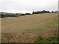
Lodon Valley fields
The course of the infant River Lodon is marked by the trees in the middle of the picture.
Image: © Peter Whatley
Taken: 14 Oct 2008
0.19 miles
3
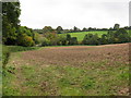
Farmland beside the River Lodon
Farmland beside the River Lodon near Pencombe.
Image: © Philip Halling
Taken: 11 Nov 2016
0.21 miles
4
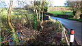
Hyde Bridge
The minor road from Bromyard to Pencombe at the point where it crosses the Lodon.
Image: © Jonathan Billinger
Taken: 16 Dec 2014
0.22 miles
5
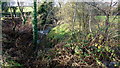
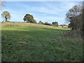
River Lodon
Looking north, upstream, from Hyde Bridge.
Image: © Jonathan Billinger
Taken: 16 Dec 2014
0.22 miles