
IMAGES TAKEN NEAR TO
BROMYARD, HR7 4QQ
Introduction
This page details the photographs taken nearby to HR7 4QQ by members of the Geograph project.
The Geograph project started in 2005 with the aim of publishing, organising and preserving representative images for every square kilometre of Great Britain, Ireland and the Isle of Man.

There are currently over 7.5m images from over14,400 individuals and you can help contribute to the project by visiting https://www.geograph.org.uk
Image Map
Images are licensed for reuse under creativecommons.org/licenses/by-sa/2.0
Notes
- Clicking on the map will re-center to the selected point.
- The higher the marker number, the further away the image location is from the centre of the postcode.
Image Listing (10 Images Found)
Images are licensed for reuse under creativecommons.org/licenses/by-sa/2.0
Image
Details
Distance

2

A44 climbing out of Bromyard toward Worcester
Image: © Peter Whatley
Taken: 25 Oct 2011
0.09 miles
3

Oak tree and rows of polythene
An oak tree on the skyline in a field of polythene which is used to warm the soil to stimulate earlier growth. Here the field is viewed from beside at A44 just east of Bromyard. There are a couple of fields with this polythene which I first spotted whilst driving about three miles to the north of Bromyard.
Image: © Philip Halling
Taken: 3 Jun 2018
0.13 miles
4

Oak tree and rows of polythene
An oak tree on the skyline in a field of polythene which is used to warm the soil to stimulate earlier growth. Here the field is viewed from beside at A44 just east of Bromyard. There are a couple of fields with this polythene which I first spotted whilst driving about three miles to the north of Bromyard.
Image: © Philip Halling
Taken: 3 Jun 2018
0.13 miles
5
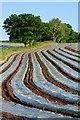
Polythene strips in a field
A field of polythene which is used to warm the soil stimulate to earlier growth. Here the field is viewed from beside at A44 just east of Bromyard. There are a couple of fields with this polythene which I first spotted whilst driving about three miles to the north of Bromyard.
Image: © Philip Halling
Taken: 3 Jun 2018
0.13 miles

8
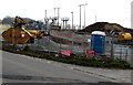
Electricity substation behind a construction site in Bromyard
Viewed from the A44 near the Avenbury Lane junction http://www.geograph.org.uk/photo/4391390 in mid March 2015.
Image: © Jaggery
Taken: 19 Mar 2015
0.25 miles
9
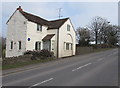
Old Toll House, Bromyard
Alongside the A44 near Petty Bridge over the River Frome near the eastern edge of Bromyard.
Viewed from the corner of Avenbury Lane. http://www.geograph.org.uk/photo/4391390
Image: © Jaggery
Taken: 19 Mar 2015
0.25 miles
10
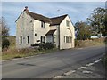
The Old Toll House
The Old Toll House on the A44 on the east side of Bromyard.
Image: © Philip Halling
Taken: 11 Nov 2016
0.25 miles