IMAGES TAKEN NEAR TO
The Downs, BROMYARD, HR7 4NY
Introduction
This page details the photographs taken nearby to HR7 4NY by members of the Geograph project.
The Geograph project started in 2005 with the aim of publishing, organising and preserving representative images for every square kilometre of Great Britain, Ireland and the Isle of Man.

There are currently over 7.5m images from over14,400 individuals and you can help contribute to the project by visiting https://www.geograph.org.uk
Image Map
Images are licensed for reuse under creativecommons.org/licenses/by-sa/2.0
Notes
- Clicking on the map will re-center to the selected point.
- The higher the marker number, the further away the image location is from the centre of the postcode.
Image Listing (13 Images Found)
Images are licensed for reuse under creativecommons.org/licenses/by-sa/2.0
Image
Details
Distance
2
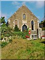
Wesleyan Methodist Chapel, Bromyard Downs
This is dated 1886. It served a settlement of scattered houses built on common land. It seems to have been closed and converted to a house between 2000 and 2009.
Image: © Humphrey Bolton
Taken: 17 Mar 2000
0.06 miles
3
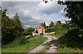
Methodist Chapel, Bromyard Downs
Looks like it has been converted into a private dwelling.
Image: © Bob Embleton
Taken: 26 Sep 2007
0.07 miles
4
The north-eastern approach to Bromyard (B4203)
Image: © Andrew Longton
Taken: 26 Aug 2005
0.12 miles

6
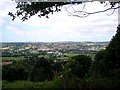
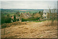
Bromyard from Bromyard Downs
Looking westwards from Bromyard Downs provides a view of the whole town.
Image: © Trevor Rickard
Taken: 11 Jul 2007
0.18 miles
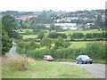
7
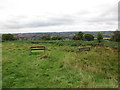
Benches with a view over Bromyard
Some cutting down of trees took place in this area a few years ago. The trees had grown up after grazing was abandoned in this area and the view was rapidly disappearing.
Image: © Jonathan Thacker
Taken: 19 Sep 2016
0.22 miles
8

Woodland, Bromyard Downs
Below the road, much of the common is now wooded following the cessation of grazing.
Image: © Richard Webb
Taken: 16 Feb 2019
0.22 miles
9
Bromyard viewed from the Bromyard Downs
Bromyard Downs is a 114 hectares area of common land, it rises to over 700 feet, overlooking the town of Bromyard.
Image: © Mat Fascione
Taken: 6 Jun 2021
0.22 miles
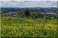
10

Seats at Bromyard Downs
Bromyard Downs is a 114 hectares area of common land, it rises to over 700 feet, overlooking the town of Bromyard.
Image: © Mat Fascione
Taken: 28 Jul 2020
0.23 miles