IMAGES TAKEN NEAR TO
Collington, BROMYARD, HR7 4NA
Introduction
This page details the photographs taken nearby to HR7 4NA by members of the Geograph project.
The Geograph project started in 2005 with the aim of publishing, organising and preserving representative images for every square kilometre of Great Britain, Ireland and the Isle of Man.

There are currently over 7.5m images from over14,400 individuals and you can help contribute to the project by visiting https://www.geograph.org.uk
Image Map
Images are licensed for reuse under creativecommons.org/licenses/by-sa/2.0
Notes
- Clicking on the map will re-center to the selected point.
- The higher the marker number, the further away the image location is from the centre of the postcode.
Image Listing (6 Images Found)
Images are licensed for reuse under creativecommons.org/licenses/by-sa/2.0
Image
Details
Distance
1
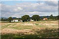
Church House Farm
Viewed over stubble.
Image: © Bob Embleton
Taken: 26 Sep 2007
0.17 miles
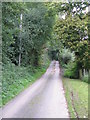
3

Field near Ripplewood
Long narrow field near Ripplewood.
Image: © Philip Halling
Taken: 30 Nov 2013
0.19 miles
4
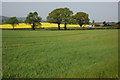
Farmland near Church House Farm, Collingwood
Image: © Philip Halling
Taken: 21 Apr 2007
0.20 miles
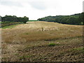
6

Church House Farm
Arable land beside Church House Farm near Collington.
Image: © Philip Halling
Taken: 30 Nov 2013
0.24 miles