IMAGES TAKEN NEAR TO
Avenbury, BROMYARD, HR7 4LA
Introduction
This page details the photographs taken nearby to HR7 4LA by members of the Geograph project.
The Geograph project started in 2005 with the aim of publishing, organising and preserving representative images for every square kilometre of Great Britain, Ireland and the Isle of Man.

There are currently over 7.5m images from over14,400 individuals and you can help contribute to the project by visiting https://www.geograph.org.uk
Image Map
Images are licensed for reuse under creativecommons.org/licenses/by-sa/2.0
Notes
- Clicking on the map will re-center to the selected point.
- The higher the marker number, the further away the image location is from the centre of the postcode.
Image Listing (13 Images Found)
Images are licensed for reuse under creativecommons.org/licenses/by-sa/2.0
Image
Details
Distance
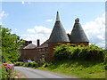
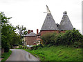
2

Avenbury hop kilns
Still an important crop in East Herefordshire, this twin roundel known in the south-east of England as oast house, has been converted to residential use.
Image: © Jonathan Billinger
Taken: 24 Dec 2014
0.02 miles
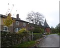
3
The Hop Kilns Avenbury Court, Avenbury
Image: © Oast House Archive
Taken: 30 Aug 2015
0.03 miles
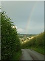
4
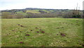
The Frome valley
Viewed from the lane to the west of Avenbury Court.
A mole has been busy in this pasture.
Image: © Jonathan Billinger
Taken: 24 Dec 2014
0.09 miles
5
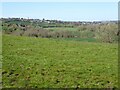
View to Bromyard
View to Bromyard from near Avenbury Court above the Frome valley.
Image: © Philip Halling
Taken: 22 Apr 2021
0.10 miles