IMAGES TAKEN NEAR TO
Much Cowarne, BROMYARD, HR7 4JW
Introduction
This page details the photographs taken nearby to HR7 4JW by members of the Geograph project.
The Geograph project started in 2005 with the aim of publishing, organising and preserving representative images for every square kilometre of Great Britain, Ireland and the Isle of Man.

There are currently over 7.5m images from over14,400 individuals and you can help contribute to the project by visiting https://www.geograph.org.uk
Image Map
Images are licensed for reuse under creativecommons.org/licenses/by-sa/2.0
Notes
- Clicking on the map will re-center to the selected point.
- The higher the marker number, the further away the image location is from the centre of the postcode.
Image Listing (5 Images Found)
Images are licensed for reuse under creativecommons.org/licenses/by-sa/2.0
Image
Details
Distance
2
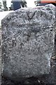
Old Milestone by the A4103, Callow Marsh, Much Cowarne parish
Carved stone post by the A4103, in parish of Much Cowarne (District), Callow Marsh; by Fir Tree PH, in tarmac, on South side of road. Erected by the Hereford turnpike trust in the 19th century.
Site re-developed and stone appears to be lost 2021.
Inscription once read:-
(Hereford)
(11)
Herefordshire SMR.
SMR Number: 56658 https://www.heritagegateway.org.uk/Gateway/Results_Single.aspx?uid=MHE28414&resourceID=101
Milestone Society National ID: HF_HFWO11
Image: © Robert Walker
Taken: 28 Jan 2012
0.04 miles
3
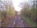
Old Road from Panks Bridge to Five Bridges
Looking east close to the hamlet of Five Bridges.
Image: © Bob Embleton
Taken: 1 Jan 2006
0.15 miles
4
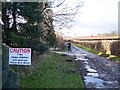
Old Road to Hope's Rough - Free Range Wife
Taken near what was the Five Bridges Inn. The route along the old road is only a right of way on foot. The well used farm track, coincident at this point, deceptively takes one in the wrong direction for a very muddy, but interesting New Years Day ramble.
Image: © Bob Embleton
Taken: 1 Jan 2006
0.16 miles
5
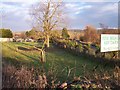
Five Bridges
A small hamlet with a now closed Inn at what was once an important T junction (or even earlier a crossroads). Now holiday accommodation http://www.fivebridgescottage.co.uk/home.php and the road "straightened" into a gentle curve on the other side of the Inn. The modern road is visible on the right of the photo.
Image: © Bob Embleton
Taken: 4 Jan 2006
0.21 miles