IMAGES TAKEN NEAR TO
Schallenge Walk, BROMYARD, HR7 4DR
Introduction
This page details the photographs taken nearby to Schallenge Walk, HR7 4DR by members of the Geograph project.
The Geograph project started in 2005 with the aim of publishing, organising and preserving representative images for every square kilometre of Great Britain, Ireland and the Isle of Man.

There are currently over 7.5m images from over14,400 individuals and you can help contribute to the project by visiting https://www.geograph.org.uk
Image Map
Images are licensed for reuse under creativecommons.org/licenses/by-sa/2.0
Notes
- Clicking on the map will re-center to the selected point.
- The higher the marker number, the further away the image location is from the centre of the postcode.
Image Listing (482 Images Found)
Images are licensed for reuse under creativecommons.org/licenses/by-sa/2.0
Image
Details
Distance
1
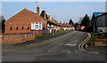
Schallenge Walk, Bromyard
Bungalows on the east side of Rowberry Street.
Schallenge looks like it could be Dutch, but my thought that Schallenge was a twin town was wrong.
I later saw this sign http://www.geograph.org.uk/photo/4396784 which shows that Bromyard is twinned with Athis de l'Orne in NW France.
Image: © Jaggery
Taken: 19 Mar 2015
0.00 miles
2

Guildway Bungalows, Bromyard
Row of bungalows extending for 45 metres east from Rowberry Street.
Image: © Jaggery
Taken: 19 Mar 2015
0.02 miles
3
Bromyard - Schallenge Walk
Off Rowberry Street.
Image: © Peter Whatley
Taken: 20 Nov 2012
0.02 miles
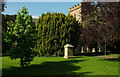
4
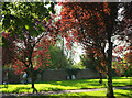
Trees, Churchyard, Bromyard
Looking left from Image
Image: © Derek Harper
Taken: 15 Jul 2021
0.03 miles
5
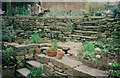
New garden wall
This garden wall in Church Street was rather boring, rising straight up from the small yard at the back of the house, with steps up right at one end. Setting the wall back in a semi-circle at half height, with steps going up the middle, has made it a far more attractive introduction to the garden. The work was carried out as an informal training day, under the supervision of a qualified instructor, a former professional dry stone waller.
Image: © CHARLES GORDON CLARK
Taken: Unknown
0.03 miles
6

Footpath, Bromyard
Bromyard footpath B9 leaves the churchyard to run between walls towards Rowberry Street.
Image: © Derek Harper
Taken: 15 Jul 2021
0.03 miles
7
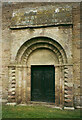
The north doorway, St Peter, Bromyard
This is a Norman doorway preserved in the 14C wall of the church. The tympanum is imitation Norman, according to Nikolaus Pevsner.
Image: © Humphrey Bolton
Taken: 1 Jan 2021
0.03 miles
8
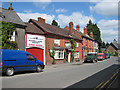
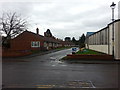
The Old Railway Inn, Bromyard
A former pub, now part of B&M Johnson, plumbing & heating merchants.
Image: © Pauline E
Taken: 18 May 2008
0.03 miles
9
Tomb, Churchyard, Bromyard
With a glimpse of the tower of St Peter's church https://historicengland.org.uk/listing/the-list/list-entry/1307758?section=official-list-entry .
Image: © Derek Harper
Taken: 15 Jul 2021
0.03 miles
10
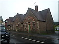
Houses on Church Street (Bromyard)
Very nice houses that I stumbled upon.
Image: © Fabian Musto
Taken: 13 Oct 2019
0.04 miles