IMAGES TAKEN NEAR TO
The Bypass, BROMYARD, HR7 4DJ
Introduction
This page details the photographs taken nearby to The Bypass, HR7 4DJ by members of the Geograph project.
The Geograph project started in 2005 with the aim of publishing, organising and preserving representative images for every square kilometre of Great Britain, Ireland and the Isle of Man.

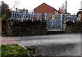
There are currently over 7.5m images from over14,400 individuals and you can help contribute to the project by visiting https://www.geograph.org.uk
Image Map
Images are licensed for reuse under creativecommons.org/licenses/by-sa/2.0
Notes
- Clicking on the map will re-center to the selected point.
- The higher the marker number, the further away the image location is from the centre of the postcode.
Image Listing (441 Images Found)
Images are licensed for reuse under creativecommons.org/licenses/by-sa/2.0
Image
Details
Distance
1
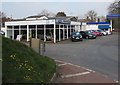
Bishops of Bromyard
Independent Ford dealership located in Bypass Garage on the north side of the A44
Bromyard Bypass, next to a Gulf filling station, shop and car wash. http://www.geograph.org.uk/photo/4391691
Image: © Jaggery
Taken: 19 Mar 2015
0.01 miles
2
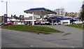
Gulf filling station, shop and car wash, Bromyard
On the north side of the A44 Bromyard Bypass.
Image: © Jaggery
Taken: 19 Mar 2015
0.02 miles
3
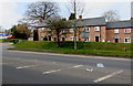
Victoria Close, Bromyard
On the north side of the A44 Bromyard Bypass.
Image: © Jaggery
Taken: 19 Mar 2015
0.03 miles
4
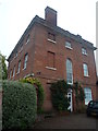
Sherford House (Bromyard)
A gorgeous Georgian building that was somehow missed by me in my Places of England episode of Bromyard, which was made nearly 2 years ago. This is the only grand Georgian building in the town, and what's more better is that Thomas Farnolls Pritchard built this around 1760!
Image: © Fabian Musto
Taken: 13 Oct 2019
0.03 miles
5
Frog Lane electricity substation, Bromyard
The Central Networks electricity substation is behind a stone wall and metal fencing.
Its identifier is FROG LANE S/S 41377. A caution notice shows the presence
of SF6 (sulphur hexafluoride, an insulating gas used in high voltage systems).
Image: © Jaggery
Taken: 19 Mar 2015
0.03 miles
6
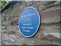
Plaque on Sherford House (Bromyard)
This plaque looks too simple--- Image
Image: © Fabian Musto
Taken: 13 Oct 2019
0.03 miles
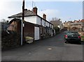
7
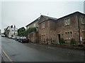
Sherford Street (Bromyard)
This street runs along from the A44 road to the Bible House. The two closest houses are the old police station and former congregational chapel. From what I heard, this used to be the former main road entrance to Bromyard.
Image: © Fabian Musto
Taken: 13 Oct 2019
0.04 miles
8
Linden Close, Bromyard
Row of houses on the north side of the A44 Bromyard Bypass.
Image: © Jaggery
Taken: 19 Mar 2015
0.04 miles
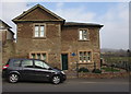
9
Former Police Station (Bromyard)
Built in 1815, this building along with its neighbour (old congregational chapel) were derelict for many decades until being saved in the 2010s. This building became a private house, and in the 2009 Google Maps streetview, the window on the right would have not existed; a garage door would have been in its place.
Image: © Fabian Musto
Taken: 13 Oct 2019
0.04 miles
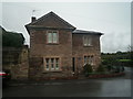
10
The Old Gaol, Bromyard
Recently renovated building in Sherford Street, now in residential use.
Image: © Jaggery
Taken: 19 Mar 2015
0.05 miles