IMAGES TAKEN NEAR TO
Shobdon, LEOMINSTER, HR6 9NY
Introduction
This page details the photographs taken nearby to HR6 9NY by members of the Geograph project.
The Geograph project started in 2005 with the aim of publishing, organising and preserving representative images for every square kilometre of Great Britain, Ireland and the Isle of Man.

There are currently over 7.5m images from over14,400 individuals and you can help contribute to the project by visiting https://www.geograph.org.uk
Image Map (Loading...)


Getting Data...Please wait
Leaflet Map data © OpenStreetMap
Images are licensed for reuse under creativecommons.org/licenses/by-sa/2.0
Notes
- Clicking on the map will re-center to the selected point.
- The higher the marker number, the further away the image location is from the centre of the postcode.
Image Listing (6 Images Found)
Images are licensed for reuse under creativecommons.org/licenses/by-sa/2.0
Image
Details
Distance
1
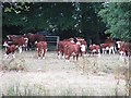
Herefords, Ty'n-y-Coed
A herd in Shobdon, 2011 was a dry year in Herefordshire and the pasture looks sparse. I had not noticed the vehicle in the wood at the time, but the cattle had.
Image: © Richard Webb
Taken: 22 Jul 2011
0.04 miles
3
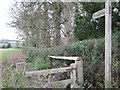
Old Milestone by the B4362, near Ty'n-y-Coed, Shobdon parish
Carved stone post by the B4362, in parish of SHOBDON (District), Ty'n-y-Coed, North End Farm, in ditch, on South side of road. Presteigne long tombstone, erected by the Presteigne turnpike trust in the 19th century.
Inscription reads:-
LEMSTER
7
PRESTEIGN
7
{break}
LONDON
144
KINGTON
9
LUDLOW 11
Herefordshire SMR.
SMR Number: 31916 https://www.heritagegateway.org.uk/Gateway/Results_Single.aspx?uid=MHE15905&resourceID=101
Milestone Society National ID: HF_LMPS07.
Image: © Ron Shackell
Taken: Unknown
0.08 miles
4
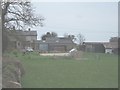
Farm between Shobdon and Mortimer's Cross
Image: © David Smith
Taken: 15 Apr 2006
0.15 miles

6
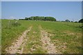
Field and Gorse Covert
View across a field to Gorse Covert.
Image: © Philip Halling
Taken: 23 May 2018
0.25 miles