IMAGES TAKEN NEAR TO
Bateman Close, LEOMINSTER, HR6 9NW
Introduction
This page details the photographs taken nearby to Bateman Close, HR6 9NW by members of the Geograph project.
The Geograph project started in 2005 with the aim of publishing, organising and preserving representative images for every square kilometre of Great Britain, Ireland and the Isle of Man.

There are currently over 7.5m images from over14,400 individuals and you can help contribute to the project by visiting https://www.geograph.org.uk
Image Map
Images are licensed for reuse under creativecommons.org/licenses/by-sa/2.0
Notes
- Clicking on the map will re-center to the selected point.
- The higher the marker number, the further away the image location is from the centre of the postcode.
Image Listing (3 Images Found)
Images are licensed for reuse under creativecommons.org/licenses/by-sa/2.0
Image
Details
Distance
2
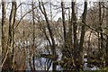
Pearl Lake, Shobdon
Eutrophic lake surrounded by carr and now an expanding caravan park. Probably a kettlehole as Shobdon has a good set of glacial deposition features. As the name suggests there was a mussel fishery here once.
Image: © Richard Webb
Taken: 13 Apr 2016
0.19 miles
3
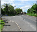
Hanbury Green junction - Shobdon, Herefordshire
Here, by the green at Shobdon, Hanbury Green joins the B4362, which leads from Presteigne to Mortimer's Cross and Orleton, in this quiet North Herefordshire village. The B4362 was once the route of the main road from London to Aberystwyth. Nearby is Shobdon Airfield. The Shobdon Arches, away to the north of the village, are all that remain of the original Shobdon church, demolished by Viscount Bateman of Shobdon Court. Its replacement, of 18th century date but keeping the 13th century tower, has a rather elaborately decorated interior in blue and white, which has been described as 'striking'. Time photo taken 10.54 am BST (British Summer Time).
Image: © Martin Richard Phelan
Taken: 2 Jun 2013
0.25 miles