IMAGES TAKEN NEAR TO
Moor Meadow, LEOMINSTER, HR6 9NT
Introduction
This page details the photographs taken nearby to Moor Meadow, HR6 9NT by members of the Geograph project.
The Geograph project started in 2005 with the aim of publishing, organising and preserving representative images for every square kilometre of Great Britain, Ireland and the Isle of Man.

There are currently over 7.5m images from over14,400 individuals and you can help contribute to the project by visiting https://www.geograph.org.uk
Image Map (Loading...)


Getting Data...Please wait
Leaflet Map data © OpenStreetMap
Images are licensed for reuse under creativecommons.org/licenses/by-sa/2.0
Notes
- Clicking on the map will re-center to the selected point.
- The higher the marker number, the further away the image location is from the centre of the postcode.
Image Listing (21 Images Found)
Images are licensed for reuse under creativecommons.org/licenses/by-sa/2.0
Image
Details
Distance
1
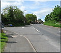
Hanbury Green junction - Shobdon, Herefordshire
Here, by the green at Shobdon, Hanbury Green joins the B4362, which leads from Presteigne to Mortimer's Cross and Orleton, in this quiet North Herefordshire village. The B4362 was once the route of the main road from London to Aberystwyth. Nearby is Shobdon Airfield. The Shobdon Arches, away to the north of the village, are all that remain of the original Shobdon church, demolished by Viscount Bateman of Shobdon Court. Its replacement, of 18th century date but keeping the 13th century tower, has a rather elaborately decorated interior in blue and white, which has been described as 'striking'. Time photo taken 10.54 am BST (British Summer Time).
Image: © Martin Richard Phelan
Taken: 2 Jun 2013
0.05 miles
2

Shobdon
Looking towards Presteigne on the B4362 from outside the oh so useful shop. A wasted stop.
Image: © Richard Webb
Taken: 16 Feb 2018
0.05 miles
3

Unpleasant shopping experience, Shobdon
The shop in Shobdon. I was refused service as I was down to my last tenner and it was a Clydesdale. They even had a sign up as if they were proud of it. Oh well, Kington's gain - spent more than a tenner there.
(Last time, and I think it was also under the Premier sign was in 1999! To think it still happens).
Image: © Richard Webb
Taken: 16 Feb 2018
0.08 miles

5
Milestone, Shobdon
An old looking one with the mileage to London and a sensible spelling of Leominster. Sometimes it is spelt Lempster as well.
Image: © Richard Webb
Taken: 27 Jul 2015
0.14 miles
6

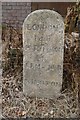
Old Milestone by the B4362, Presteigne Road, Shobdon
Carved stone post by the B4362, in parish of SHOBDON (District), 60m East of school entrance, against barn on verge, on North side of road. Presteigne long tombstone, erected by the Presteigne turnpike trust in the 19th century.
Inscription reads:-
LONDON
148
PRESTEIGN
6
LEMSTER
8
KINGTON
8
Herefordshire SMR listed.
SMR Number: 56708 https://www.heritagegateway.org.uk/Gateway/Results_Single.aspx?uid=MHE28464&resourceID=101
Milestone Society National ID: HF_LMPS08
Image: © M Faherty
Taken: 7 Sep 2008
0.15 miles
7

Shobdon village green
The village green in Shobdon is situated by the B4362 road to Presteigne. The green consists of the war memorial, cider press and crush.
Image: © Fabian Musto
Taken: 8 Nov 2020
0.23 miles
8

Information board at Shobdon village green
This information board includes an OS map of Shobdon and surrounding fields. The map features Aymestrey (centre-right) and Staunton-on-Arrow (centre-left).
Image: © Fabian Musto
Taken: 8 Nov 2020
0.23 miles
9

Poppy man and dog at Shobdon village green
These two figures covered in poppies were resting on a bench in the village green at Shobdon.
Image: © Fabian Musto
Taken: 8 Nov 2020
0.23 miles
10
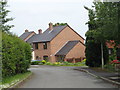
Shobdon - Hanbury Green estate
Modern Housing to the south of the main route through this old village.
Image: © Peter Whatley
Taken: 29 May 2008
0.23 miles