IMAGES TAKEN NEAR TO
Shobdon, LEOMINSTER, HR6 9NJ
Introduction
This page details the photographs taken nearby to HR6 9NJ by members of the Geograph project.
The Geograph project started in 2005 with the aim of publishing, organising and preserving representative images for every square kilometre of Great Britain, Ireland and the Isle of Man.

There are currently over 7.5m images from over14,400 individuals and you can help contribute to the project by visiting https://www.geograph.org.uk
Image Map (Loading...)


Getting Data...Please wait
Leaflet Map data © OpenStreetMap
Images are licensed for reuse under creativecommons.org/licenses/by-sa/2.0
Notes
- Clicking on the map will re-center to the selected point.
- The higher the marker number, the further away the image location is from the centre of the postcode.
Image Listing (4 Images Found)
Images are licensed for reuse under creativecommons.org/licenses/by-sa/2.0
Image
Details
Distance
2
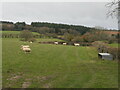
Sheep above Shobdon
On the limestone dip slope near Belgate.
Image: © Richard Webb
Taken: 5 Dec 2021
0.13 miles
3
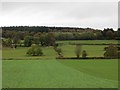
Beneath Shobdon Hill
Arable land on the dip slope, a contrast to the steep scarp beyond the woods.
Image: © Richard Webb
Taken: 24 Oct 2014
0.19 miles
4
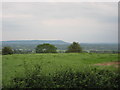
From Shobdon Hill
View over the Wye and Arrow valleys
Image: © David M Jones
Taken: 31 May 2008
0.24 miles