IMAGES TAKEN NEAR TO
Stansbatch, LEOMINSTER, HR6 9LJ
Introduction
This page details the photographs taken nearby to HR6 9LJ by members of the Geograph project.
The Geograph project started in 2005 with the aim of publishing, organising and preserving representative images for every square kilometre of Great Britain, Ireland and the Isle of Man.

There are currently over 7.5m images from over14,400 individuals and you can help contribute to the project by visiting https://www.geograph.org.uk
Image Map (Loading...)


Getting Data...Please wait
Leaflet Map data © OpenStreetMap
Images are licensed for reuse under creativecommons.org/licenses/by-sa/2.0
Notes
- Clicking on the map will re-center to the selected point.
- The higher the marker number, the further away the image location is from the centre of the postcode.
Image Listing (15 Images Found)
Images are licensed for reuse under creativecommons.org/licenses/by-sa/2.0
Image
Details
Distance
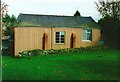
3
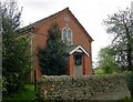
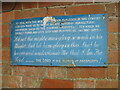
Baptist Chapel, Stansbatch
Dates from 1863. The right hand side of the chapel is made from corrugated iron. Chapels like this have closed in their thousands, but this one is still regularly used and is well cared for.
Image: © Philip Pankhurst
Taken: 30 Apr 2008
0.08 miles
4
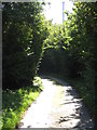
Herefordshire Trail near Upper Tan House
Image: © Peter Whatley
Taken: 27 Sep 2011
0.09 miles
6
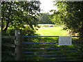
German Shepherds running loose!
Men in Lederhosen on the rampage? Scary stuff.
Image: © Peter Whatley
Taken: 27 Sep 2011
0.11 miles
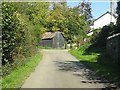
8
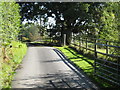
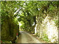
Narrow lane to Denby Hall
Looking south from the main road at Stansbatch.
Image: © Jonathan Billinger
Taken: 5 May 2012
0.15 miles
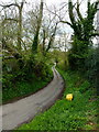
9
Remains of old railway bridge near Horseway Head
The track from where the picture was taken forms part of the Mortimer Trail, a long distance path that runs from Kington to Ludlow Castle.
Image: © Phil Catterall
Taken: 12 Aug 2006
0.16 miles
10
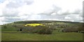
Trackbed of GWR branch to Presteigne at Horseway Head
The bed of the old railway, closed finally in 1964, snakes away towards Presteigne. Looking towards Stansbatch and Wapley Hill.
Image: © Philip Pankhurst
Taken: 29 Apr 2008
0.17 miles