IMAGES TAKEN NEAR TO
Pembridge, LEOMINSTER, HR6 9JY
Introduction
This page details the photographs taken nearby to HR6 9JY by members of the Geograph project.
The Geograph project started in 2005 with the aim of publishing, organising and preserving representative images for every square kilometre of Great Britain, Ireland and the Isle of Man.

There are currently over 7.5m images from over14,400 individuals and you can help contribute to the project by visiting https://www.geograph.org.uk
Image Map
Images are licensed for reuse under creativecommons.org/licenses/by-sa/2.0
Notes
- Clicking on the map will re-center to the selected point.
- The higher the marker number, the further away the image location is from the centre of the postcode.
Image Listing (8 Images Found)
Images are licensed for reuse under creativecommons.org/licenses/by-sa/2.0
Image
Details
Distance
1
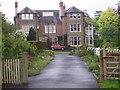
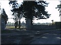
House at Twyford
Looking East from the driveway to the larger house at Twyford, by the farm.
Image: © Rob Hinkley
Taken: 13 May 2006
0.06 miles
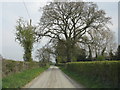
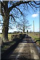
3
Looking East to Twyford
Twyford is a farm with orchards and large house NE of Pembridge.
Image: © Rob Hinkley
Taken: 13 May 2006
0.08 miles
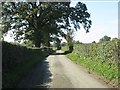
6
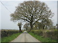
Country road near Twyford
Country road near Twyford to the north of Pembridge.
Image: © Philip Halling
Taken: 2 Feb 2018
0.16 miles
7
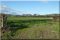
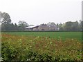
Farmland north of Pembridge
Farmland near Twyford to the north of Pembridge.
Image: © Philip Halling
Taken: 2 Feb 2018
0.19 miles